Lancaster in Lancaster County, Pennsylvania — The American Northeast (Mid-Atlantic)
Old Center Square (Penn Square)
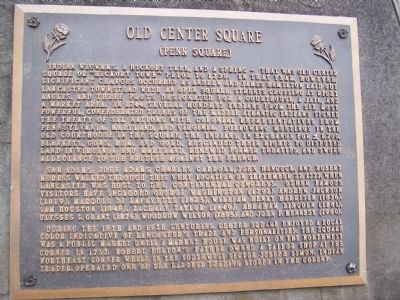
Indian wigwams, a hickory tree, and a spring - that was old center square "Hickory Town" prior to 1730. In that year, however, significant changes occurred as Andrew and James Hamilton laid out Lancaster Townstead with an open square. Streets crossing at right angles, and three plots designated for a courthouse, a jail, and a market area. In 1744, several hundred indians from the six most powerful, confederated tribes of the middle Atlantic indians signed the Treaty of Six Nations with colonial representatives from Pennsylvania, Maryland and Virginia. Following meeting in the old courthouse in the square, the indians, in exchange for £1,200, blankets, guns, rum, and gold, rescinded their rights to disputed land in Virginia and Maryland, renewed former treaties, and swore allegiance to the British against the French.
Sam Adams, John Adams, Charles Carroll, John Hancock, and Robert Morris walked through this very location on September 27, 1777, when Lancaster was host to the Continental Congress. Other famous visitors have included George Washington (1791), Andrew Jackson (1819), Marquis de Lafayette (1825), William Henry Harrison (1836), Sam Houston (1848), Zachary Taylor (1849), Abraham Lincoln (1861), Ulysses S. Grant (1876), Woodrow Wilson (1895), and John F. Kennedy (1960).
During the 18th and 19th centuries, center square enjoyed a local color indicative of Lancaster's trade and personalities. The square was a public market until a market house was built on the northwest corner in 1757. Robert Fulton's father owned a tailor shop at the northeast corner while in the southwest sector Joseph Simon, indian trader, operated one of the largest trading stores in the colony.
Topics and series. This historical marker is listed in these topic lists: Colonial Era • Industry & Commerce • Native Americans • Settlements & Settlers • War, US Revolutionary. In addition, it is included in the Former U.S. Presidents: #02 John Adams, the Former U.S. Presidents: #09 William Henry Harrison, the Former U.S. Presidents: #12 Zachary Taylor, the Former U.S. Presidents: #16 Abraham Lincoln, the Former U.S. Presidents: #18 Ulysses S. Grant, the Former U.S. Presidents: #28 Woodrow Wilson, the Former U.S. Presidents: #35 John F. Kennedy, and the Lafayette’s Farewell Tour series lists. A significant historical month for this entry is September 1861.
Location. 40° 2.282′ N, 76° 18.355′ W. Marker is in Lancaster, Pennsylvania, in Lancaster County. Marker is at the intersection of Queen Street and King Street, on the right when traveling north on Queen Street. Touch for map. Marker is in this post office area: Lancaster PA 17603, United States of America. Touch for directions.
Other nearby markers. At least 8 other markers are within
walking distance of this marker. Soldiers and Sailors Monument (here, next to this marker); Old Courthouse (here, next to this marker); Central Market (here, next to this marker); Early Transportation Routes (here, next to this marker); Lancaster's 'freedom spies' (here, next to this marker); Penn Square (a few steps from this marker); The Revolutionary War (a few steps from this marker); The War of 1812 (a few steps from this marker). Touch for a list and map of all markers in Lancaster.
Related markers. Click here for a list of markers that are related to this marker. Lancaster markers displayed together.
Credits. This page was last revised on August 1, 2020. It was originally submitted on February 4, 2008, by Bill Pfingsten of Bel Air, Maryland. This page has been viewed 1,765 times since then and 67 times this year. Photos: 1, 2. submitted on February 4, 2008, by Bill Pfingsten of Bel Air, Maryland.

