Sand Mountain Pony Express Station
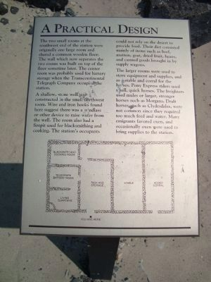
A Practical Design
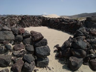
Two small rooms at the southwest end of the station were originally one large room and shared a common wood floor. The wall which now separates the two rooms was built on top of the floor some time later. The center room was probably used for battery storage when the Transcontinental Telegraph Company occupied the station.
A shallow, stone well was constructed in the small northwest room. Wire and iron hooks found here suggest there was a windlass or other device to raise water from the well. The room also had a firepit used for blacksmithing and cooking. The station's occupants could not rely on the desert to provide food. Their diet consisted mainly of items such as beef, mutton, goat, dries fruit, beans and canned goods brought in by supply wagons.
The larger rooms were used to store equipment and supplies, and as a stable and corral for the horses. Pony Express riders used small, quick horses. The freighters used mules or larger, stronger horses such as Morgans. Draft horses, such as Clydesdales, were not common since they required too much feed and water. Many emigrants favored oxen, and occasionally oxen were used to bring supplies to the station.
Topics and series. This historical marker is listed in these topic lists: Communications • Roads & Vehicles
Location. 39° 17.462′ N, 118° 25.09′ W. Marker is in Fallon, Nevada, in Churchill County. Marker can be reached from US Highway 50 (U.S. 50). Sand Mountain is about 20-25 miles east of Fallon, NV off of Highway 50. Take the road (north) that leads toward Sand Mountain Recreation Area, follow the signs to the Pony Express Station parking area, then walk. Touch for map. Marker is in this post office area: Fallon NV 89406, United States of America. Touch for directions.
Other nearby markers. At least 6 other markers are within 11 miles of this marker, measured as the crow flies. Swift Steeds Tie East to West (about 700 feet away, measured in a direct line); What Are Those Rocks Out There? (about 800 feet away); Sand Mountain (approx. 1.1 miles away); Helicopter Antisubmarine Squadron Four Crash Site (approx. 2.3 miles away); Pony Express Route (approx. 8.3 miles away); Fairview (approx. 10.9 miles away).
Also see . . . Pony Express Station Ruins Are Hiding In The Nevada Desert. Only in Your State entry:
Famed British explorer Sir Richard Burton wasn't much impressed by the Sand Springs Pony Express Station when he spent a night there on October 17, 1860. "The water near this vile hold was thick and stale with sulphury salts: it blistered even the hands,"... (Submitted on December 7, 2018, by Barry Swackhamer of Brentwood, California.) (Submitted on February 17, 2021, by Larry Gertner of New York, New York.)
Additional keywords. pony express
Credits. This page was last revised on February 17, 2021. It was originally submitted on January 17, 2012, by Barry Swackhamer of Brentwood, California. This page has been viewed 990 times since then and 34 times this year. Last updated on December 5, 2018, by Teri Ligon of Carson City, Nevada. Photos: 1, 2, 3, 4, 5, 6, 7. submitted on January 17, 2012, by Barry Swackhamer of Brentwood, California.
