Skiatook in Osage County, Oklahoma — The American South (West South Central)
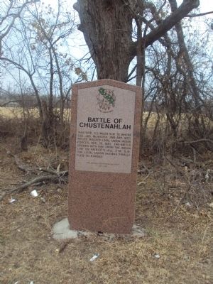
Battle of Chustenahlah
Erected 1995 by Oklahoma Historical Society. (Marker Number 167.)
Topics and series. This historical marker is listed in these topic lists: Native Americans • War, US Civil. In addition, it is included in the Oklahoma Historical Society series list. A significant historical date for this entry is December 26, 1970.
Location. 36° 22.116′ N, 96° 3.568′ W. Marker is in Skiatook, Oklahoma, in Osage County. Marker is on W.C. Rogers Boulevard (State Highway 20). This marker is located in a small turn-off to the right side of the road when westbound on SR 20 from Skiatook. Touch for map. Marker is in this post office area: Skiatook OK 74070, United States of America. Touch for directions.
Other nearby markers. At least 6 other markers are within 14 miles of this marker, measured as the crow flies. Hillside Mission (approx. 5.6 miles away); Battle of Chusto-Talasah (approx. 6.9 miles away); Battle of Chusto-Talasah or "Caving Banks" (approx. 8½ miles away); Colonial Garden (approx. 13.6 miles away); Simón Bolívar (approx. 13.6 miles away); The Gillies (approx. 13.6 miles away).
Credits. This page was last revised on February 17, 2023. It was originally submitted on February 5, 2012, by Michael Manning of Woodlawn, Tennessee. This page has been viewed 1,335 times since then and 89 times this year. Last updated on February 16, 2023, by J.w.roberts of Skiatook, Oklahoma. Photos: 1, 2, 3. submitted on February 5, 2012, by Michael Manning of Woodlawn, Tennessee. • J. Makali Bruton was the editor who published this page.
Editor’s want-list for this marker. A photo of the marker and the surrounding area in context. • Can you help?


