Auburn in Placer County, California — The American West (Pacific Coastal)
Central Square
Central Square:
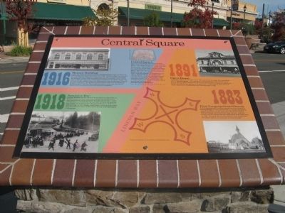
After the Central Pacific Railroad built a Train Depot, over a mile away and up the hill from Old Auburn, civic leaders looked for a way to connect the two areas. The city planners took a map and located a halfway point between the Placer County Court House and the East Auburn Train Depot. Over time, this spot became known as Central Square, as it is today.
When concrete sidewalks first appeared circa 1905 in Central Square the halfway point was defined by a medallion referenced in legal descriptions for this block of properties, has survived many years of sidewalk repairs and is surprisingly still there today.
Can you find the medallion?
Hint: Lat 38° 53’ 56” N. Lon 121° 4’ 14” W. El. 1117’
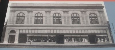
1916 – Masonic Building
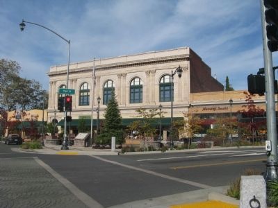
Today, the oldest remaining building in Central Square began as William G. Lee’s single story department store circa 1906. Eureka Lodge #16, Free and Accepted Masons, chartered on November 17, 1851 in Auburn, purchased this building in 1913. They completed the addition of the two-story meeting room and social hall on top of the original single-story building in 1916. The architect for the addition was A.D. Fellows and it was constructed by Herdan Brothers of Auburn. The facade is made of terra cotta from the Gladding McBean plant in Lincoln. The building has been continuously used by the Masons and the Auburn Community since its completion.
1918 – Armistice Day:
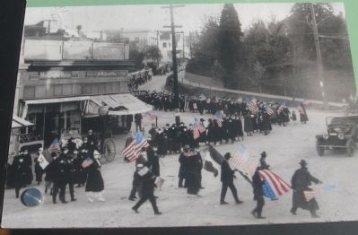
Central Square was the scene of a spontaneous celebration by Auburn residents when news was received that the Germans had signed the Armistice-Agreement ending World War I. Look closely and you will see that many of the marchers were wearing face masks due to fear of the Influenza Epidemic of 1918-1919. Veterans Day, as it is officially called today, is still observed when Auburn’s Veterans Day Parade passes through Central Square in November.
1891 – Opera House:
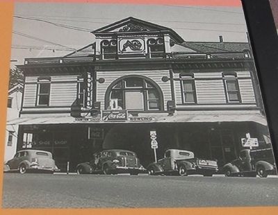
The Auburn Opera House was built in 1891 just across the street from the halfway point in Central Square. This cultural icon hosted the likes of John Philip Souza and his Marching Band along with many other distinguished entertainers. Many civic events and high school activities took place here. In later years it was home to a movie theatre and a bowling alley until it burned down in 1957.
1883 – First Congregational Church:
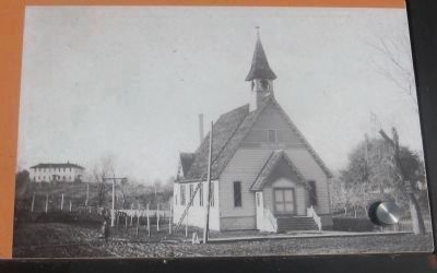
First Congregational Church’s original home was located at Central Square on the property that is currently occupied by Wells Fargo Bank. To the upper left in the photo is Sierra Normal College (currently Placer High School). Both the church and the college had their dedications at the same time in 1883. The area was so wet during the rainy season that the church took on the nickname of “Swamp Angel”.
Topics. This historical marker is listed in these topic lists: Arts, Letters, Music • Churches & Religion • Entertainment • Industry & Commerce • Railroads & Streetcars • War, World I. A significant historical month for this entry is November 1911.
Location. 38° 53.924′ N, 121° 4.252′ W. Marker is in Auburn, California, in Placer County. Marker is on Lincoln Way (State Highway 49) near High Street, on the right when traveling north. Touch for map. Marker is at or near this postal address: 972 California 49, Auburn CA 95603, United States of America. Touch for directions.
Other nearby markers. At least 8 other markers are within walking distance of this marker. The Auburn Masonic Hall (within shouting distance of this marker); Auburn Public Library (about 500 feet away, measured in a direct line); Auburn Drug Company (approx. 0.2 miles away); Lincoln Avenue Businesses (approx. 0.2 miles away); Odd Fellows Hall, Auburn Lodge #7 (approx. 0.2 miles away); Gold Discovered Just Downstream in Auburn Ravine! - Why Daylight North Rich Ravine? (approx. 0.2 miles away); The Historic Cooper Amphitheater (approx. ¼ mile away); Veteran's Memorial Hall (approx. ¼ mile away). Touch for a list and map of all markers in Auburn.
Credits. This page was last revised on January 5, 2020. It was originally submitted on February 6, 2012, by Syd Whittle of Mesa, Arizona. This page has been viewed 637 times since then and 37 times this year. Photos: 1, 2, 3, 4, 5, 6. submitted on February 6, 2012, by Syd Whittle of Mesa, Arizona.
Editor’s want-list for this marker. Photo of the Halfway Medallion embedded in the sidewalk. • Can you help?
