Okay in Wagoner County, Oklahoma — The American South (West South Central)
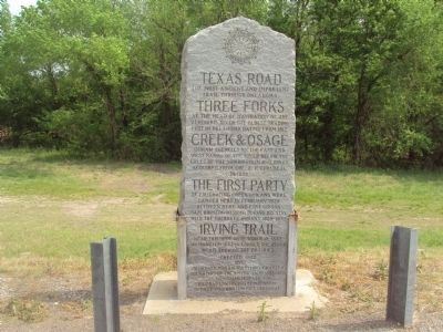
Texas Road
Erected 1932 by Muskogee Indian Territory Chapter Daughters of the American Revolution to commemorate Washington Irving Centennial, George Washington Bicentennial
Erected 1932 by Muskogee Indian Territory Chapter, Daughters of the American Revolution.
Topics and series. This historical marker is listed in these topic lists: Native Americans • Roads & Vehicles • Settlements & Settlers. In addition, it is included in the Daughters of the American Revolution series list. A significant historical month for this entry is February 1828.
Location. 35° 50.457′ N, 95° 19.072′ W. Marker is in Okay, Oklahoma, in Wagoner County. Marker is on North York Road (State Highway 16), on the left when traveling south. Marker is on east side of SR 16 near the north end of the Verdigris River bridge. Touch for map. Marker is in this post office area: Okay OK 74446, United States of America. Touch for directions.
Other nearby markers. At least 8 other markers are within 5 miles of this marker, measured as the crow flies. Memorial U.S.S. Shark (SS174) (approx. 3.3 miles away); Troops L & M, Roosevelt's Rough Riders (approx. 3.3 miles away); Vietnam War Memorial (approx. 3.3 miles away); War Memorial (approx. 3.3 miles away); Fort Davis (approx. 3.8 miles away); Fort Gibson Stockade Well (approx. 4.3 miles away); Fort Gibson (approx. 4.3 miles away); Telephones in 1886 (approx. 4.3 miles away).
Credits. This page was last revised on June 16, 2016. It was originally submitted on February 12, 2012, by Michael Manning of Woodlawn, Tennessee. This page has been viewed 2,030 times since then and 323 times this year. Photo 1. submitted on February 12, 2012, by Michael Manning of Woodlawn, Tennessee. • Craig Swain was the editor who published this page.
Editor’s want-list for this marker. A photo of the marker and the surrounding area in context. • Can you help?
