Downtown in Hartford in Hartford County, Connecticut — The American Northeast (New England)
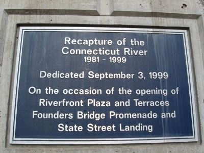
Recapture of the Connecticut River
Connecticut River
1981 – 1999
Dedicated September 3, 1999
On the occasion of the opening of
Riverfront Plaza and Terraces
Founders Bridge Promenade and
State Street Landing
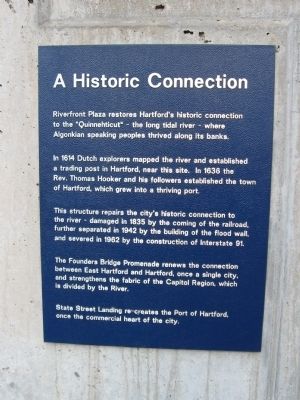
[ left plaque ]
In 1614 Dutch explorers mapped the river and established a trading post in Hartford, near this site. In 1636 the Rev. Thomas Hooker and his followers established the town of Hartford, which grew into a thriving port.
This structure repairs the city's historic connection to the river – damaged in 1835 by the coming of the railroad, further separated in 1942 by the building of the flood wall, and severed in 1962 by the construction on Interstate 91.
The Founders Bridge Promenade renews the connection between East Hartford and Hartford, once a single city, and strengthens the fabric of the Capitol Region, which is divided by the river.
State Street Landing re-creates the Port of Hartford, once the commercial heart of the city.
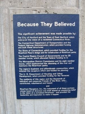
[ right plaque ]
The City of Hartford and the Town of East Hartford, which embraced the vision of a reclaimed Connecticut River.
The Connecticut Department of Transportation and the Federal Highway Administration, which provided funding and built these structures;
The State of Connecticut, which provided funding for Riverfront Plaza's design and for construction of Riverfront parks;
The Capitol Region Council of Governments and its 29 member towns, which allocated federal funding to it;
The Metropolitan District Commission and its eight member towns, which implemented the cleansing of the river and maintains the Riverfront parks;
The region's businesses and philanthropic communities, which initiated the recapture effort and funded its planning;
The U.S. Department of Housing and Urban Development which provided funding for the Terraces;
The residents of this region and the thousands of individual and corporate Friends of the River, who contributed, volunteered and hoped; and
Riverfront Recapture, Inc., the instrument of all these partners whose board of directors and staff shared an unwavering belief in the vision of a revitalized Riverfront – and provided the leadership and inspiration to make it happen.
Erected 1999.
Topics. This historical marker is listed in this topic
list: Charity & Public Work. A significant historical date for this entry is September 3, 1872.
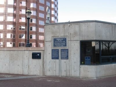
Location. 41° 45.919′ N, 72° 40.134′ W. Marker is in Hartford, Connecticut, in Hartford County. It is in Downtown. Marker can be reached from Columbus Boulevard near State Street, on the right when traveling north. Located on the Founders Bridge Promenade. Touch for map. Marker is in this post office area: Hartford CT 06103, United States of America. Touch for directions.
Other nearby markers. At least 8 other markers are within walking distance of this marker. William H. Mortensen Riverfront Plaza (here, next to this marker); a different marker also named William H. Mortensen Riverfront Plaza (within shouting distance of this marker); The Founders Bridge (about 400 feet away, measured in a direct line); Lincoln Meets Stowe (about 500 feet away); Bell of the U.S.S. Hartford (about 700 feet away); Sophie Tucker (about 700 feet away); Union (approx. 0.2 miles away); Bob Steele (approx. 0.2 miles away). Touch for a list and map of all markers in Hartford.
Also see . . . Riverfront Recapture. (Submitted on February 13, 2012, by Michael Herrick of Southbury, Connecticut.)
Credits. This page was last revised on February 10, 2023. It was originally submitted on February 13, 2012, by Michael Herrick of Southbury, Connecticut. This page has been viewed 650 times since then and 13 times this year. Photos: 1, 2, 3, 4. submitted on February 13, 2012, by Michael Herrick of Southbury, Connecticut.


