Green Hills in Nashville in Davidson County, Tennessee — The American South (East South Central)
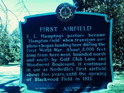
First Airfield
Erected 1970 by The Historical Commission of Metropolitan Nashville and Davidson County. (Marker Number 31.)
Topics and series. This historical marker is listed in these topic lists: Air & Space • War, World I. In addition, it is included in the Tennessee, The Historical Commission of Metropolitan Nashville and Davidson County series list. A significant historical year for this entry is 1921.
Location. Marker has been reported missing. It was located near 36° 6.995′ N, 86° 49.033′ W. Marker was in Nashville, Tennessee, in Davidson County. It was in Green Hills. Marker was on Hampton Avenue west of 23rd Avenue, on the right when traveling east. Touch for map. Marker was at or near this postal address: 2305 Hampton Ave, Nashville TN 37215, United States of America. Touch for directions.
Other nearby markers. At least 8 other markers are within walking distance of this location. Natchez Trace (approx. 0.3 miles away); Woodmont Estates (approx. 0.4 miles away); Battle of Nashville (approx. half a mile away); Lieutenant General Alexander Peter Stewart (approx. half a mile away); Redoubt One (approx. half a mile away); Battle of Nashville Confederate Line (approx. 0.7 miles away); Hillsboro High School (approx. 0.7 miles away); Assault on Montgomery Hill (approx. 0.8 miles away). Touch for a list and map of all markers in Nashville.
Additional commentary.
1. Missing marker
When viewing the location on Google Maps street view on 6/11/22, I saw that the marker is missing. I verified the former location using the photo on this page (taken 3/10/12) and comparing it to the street view image, which is dated February 2022 and shows a house under construction at this address. I have not driven past this address since the street view image was taken, so I don't know whether the marker has been reinstalled or replaced recently. I hope the marker can be put back up if its location is known. The existence of Hampton Field is a relatively little-known fact about this area of Nashville.
— Submitted June 11, 2022, by David M. Bullock of Brentwood, Tennessee.
Credits. This page was last revised on February 7, 2023. It was originally submitted on March 10, 2012, by Kevin Hoch of Waco, Texas. This page has been viewed 938 times since then and 56 times this year. Photos: 1, 2. submitted on March 10, 2012, by Kevin Hoch of Waco, Texas. • Bernard Fisher was the editor who published this page.
Editor’s want-list for this marker. A photo of the marker upon it being replaced or returned. • Can you help?

