Near Longwood in Seminole County, Florida — The American South (South Atlantic)
Seminole County
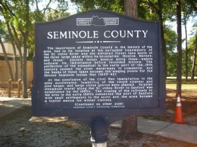
The importance of Seminole County in the history of the area lies in its location at the navigable headwaters of the St. Johns River and the elevated forest land south of the three large lakes within its boundaries: Monroe, Harney, and Jesup. Ancient Indian mounds along these waters indicate its importance before recorded history. The perfection of the steamboat in the early part of the 19th century opened the river waterways to commerce, and the banks of these lakes became the staging points for the Second Seminole Indian War (1835-42).
At the conclusion of the Civil War immigration to the area accelerated, lumbering of the virgin cypress and pine began, and large citrus groves were planted. Regular steamboat travel along the St. Johns River to Sanford was established by the 1850's. The coming of the railroads to the area in the early 1880's connected the port of Sanford with small settlements to the south and the area became a tourist mecca for winter visitors.
Reverse:
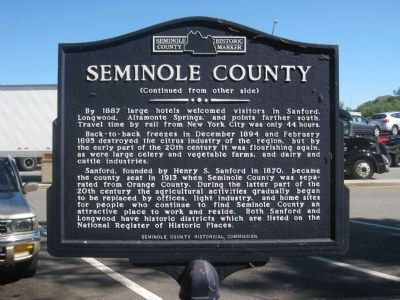
By 1887 large hotels welcomed visitors in Sanford, Longwood, Altamonte Springs, and points farther south. Travel time by rail from New York City was only 44 hours.
Back-to-back freezes in December 1894 and February 1895 destroyed the citrus industry of the region, but by the early part of the 20th century it was flourishing again, as were large celery and vegetable farms, and dairy and cattle industries.
Sanford, founded by Henry S. Sanford in 1870, became the county seat in 1913 when Seminole County was separated from Orange County. During the latter part of the 20th century the agricultural activities gradually began to be replaced by offices, light industry, and home sites for people who continue to find Seminole County an attractive place to work and reside. Both Sanford and Longwood have historic districts which are listed on the National Register of Historic Places.
Erected by the Seminole County Historical Commission.
Topics. This historical marker is listed in these topic lists: Industry & Commerce • Political Subdivisions • Wars, US Indian. A significant historical month for this entry is February 1895.
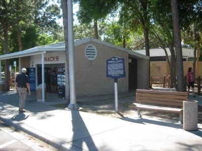
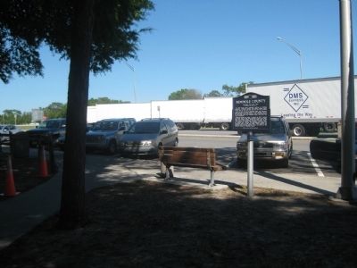
Location. 28° 42.11′ N, 81° 23.073′ W. Marker is near Longwood, Florida, in Seminole County. Marker can be reached from Interstate 4 at milepost 95 east of State Road 434, on the right when traveling west. The marker is located at the Richey Green Interstate Rest Facility along westbound I-4. Touch for map. Marker is in this post office area: Longwood FL 32779, United States of America. Touch for directions.
Other nearby markers. At least 8 other markers are within 3 miles of this marker, measured as the crow flies. Florida Honors and Remembers our POW’s and MIA’s (a few steps from this marker); Orange Belt Railway (approx. 1˝ miles away); a different marker also named Seminole County (approx. 1.7 miles away); a different marker also named Florida Honors and Remembers our POW’s and MIA’s (approx. 1.7 miles away); William Bartram Trail (approx. 1.7 miles away); The Senator II (approx. 2 miles away); Heroes Monument (approx. 2.1 miles away); Historic Longwood/E.W. Henck (approx. 2.2 miles away). Touch for a list and map of all markers in Longwood.
More about this marker. The double-sided marker is capped on both sides with the Seminole County Historic Marker logo. It is identical to a marker which is located at Seminole County's eastbound I-4 rest area.
Regarding Seminole County. Seminole County became the 50th of Florida's 67 counties on April 25, 1913.
Also see . . .
1. Seminole County page on Wikipedia. (Submitted on April 2, 2012, by Glenn Sheffield of Tampa, Florida.)
2. Seminole County Government. (Submitted on April 2, 2012, by Glenn Sheffield of Tampa, Florida.)
Credits. This page was last revised on January 12, 2024. It was originally submitted on April 2, 2012, by Glenn Sheffield of Tampa, Florida. This page has been viewed 995 times since then and 46 times this year. Photos: 1, 2, 3, 4. submitted on April 2, 2012, by Glenn Sheffield of Tampa, Florida. • Craig Swain was the editor who published this page.


