Rochester in Beaver County, Pennsylvania — The American Northeast (Mid-Atlantic)
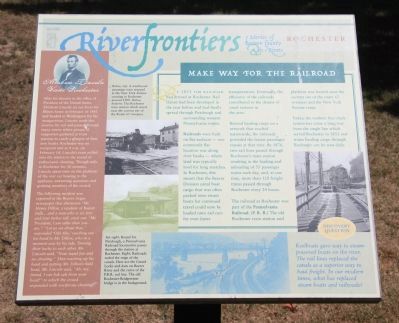
Make Way for the Railroad
Riverfrontiers
— Stories of Beaver County & its Rivers —
By 1851 the railroad had arrived at Rochester. Rail transit had been developed in the year before and had finally spread through Pittsburgh and surrounding western Pennsylvania towns.
Railroads were built on flat surfaces - one commonly flat location was along river banks - where land was typically level for long stretches. In Rochester, this meant that the Beaver Division canal boat cargo that was often packed onto steam boats for continued travel could now be loaded onto rail cars for even faster transportation. Eventually, the efficiency of the railroads contributed to the demise of canal systems in the area.
Beyond hauling cargo on a network that reached nationwide, the railroads provided the fasted passenger transit st the time. By 1876, two rail lines passed through Rochester's main station resulting in the loading and unloading of 55 passenger trains each day, and, at one time, more than 120 freight trains passed through Rochester every 24 hours.
The railroad at Rochester was, part of the Pennsylvania Railroad. (P.R.R.) The old Rochester train station and platform was located near the current site of the route 65 overpass and the New York Avenue ramp.
Today, the modern four track system has come a long way from the single line which served Rochester in 1851 and trains hauling cargo through Rochester can be seen daily.
After his election to the office of President of the United States, Abraham Lincoln set out from his Illinois home in February of 1861 and headed to Washington for his inauguration. Lincoln made this journey by rail and passed through many towns where groups of supporters gathered at train stations to catch a glimpse of their new leader. Rochester was no exception and at 4 a.m. on February 14, Lincoln's train pulled into the station to the sound of enthusiastic cheering. Though only in Rochester for 20 minutes, Lincoln spent time on the platform of the rear car bowing to the applause, answering questions and greeting members of the crowd.
The following incident was reported in the Beaver Argus newspaper that afternoon: 'Mr. Henry Dillon, a resident of Beaver Falls...and a man who is six feet and four inches tall, cried out: "Mr. President, I am taller than you are." "Let us see about that," responded 'Old Abe,' reaching out his hand to Mr. Dillon, who in a moment was by his side. Turning their backs to each other, Mr. Lincoln said, "Now stand fair and no cheating." Then reaching up his hand and patting Mr. Dillon's bald head, Mr. Lincoln said, "Ah, my friend, I can lick salt from your head!" to which the crowd responded with vociferous cheering.'
Topics and series. This historical marker is listed in this topic list: Railroads & Streetcars. In addition, it is included in the Former U.S. Presidents: #16 Abraham Lincoln, and the Pennsylvania Railroad (PRR) series lists. A significant historical month for this entry is February 1861.
Location. 40° 41.972′ N, 80° 17.343′ W. Marker is in Rochester, Pennsylvania, in Beaver County. Marker is on Water Street west of Harrison Street, on the left when traveling north. This historical marker is located along the river front, very near the east side of the mouth of the Beaver River. It is situated on the east side of the Beaver River, a short distance upstream from where the Beaver River empties into the Ohio River. Touch for map. Marker is in this post office area: Rochester PA 15074, United States of America. Touch for directions.
Other nearby markers. At least 8 other markers are within walking distance of this marker. Logans Town (about 600 feet away, measured in a direct line); Spanning the Waters (approx. 0.2 miles away); Lewis and Clark (approx. 0.2 miles away); The Bridgewater - Rochester Bridge (approx. 0.2 miles away); Girard Locks of the Beaver Division Canal (approx. 0.2 miles away); About River Transit ... (approx. 0.2 miles away); H.C. Fry Glass Company (approx. 0.2 miles away); Rochester Lodge Number 229 (approx. ¼ mile away). Touch for a list and map of all markers in Rochester.
Credits. This page was last revised on July 21, 2021. It was originally submitted on May 8, 2012, by Dale K. Benington of Toledo, Ohio. This page has been viewed 717 times since then and 28 times this year. Photos: 1, 2, 3, 4. submitted on May 10, 2012, by Dale K. Benington of Toledo, Ohio.


