Prospect in Waldo County, Maine — The American Northeast (New England)
Where Did the Soldiers Sleep?
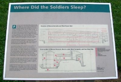
Fort Knox never had soldiers living within its walls, except for a few weeks during the Spanish American War (1898) when some Connecticut Volunteers probably camped on the parade ground or in adjacent rooms. During the Civil War, when the largest number of soldiers were assigned to Fort Knox, the fort was still under construction and not fit for occupation. As a result, when 30 soldiers arrived here in 1863 and found no place to live, they asked the quartermaster's office in Augusta for funds to build a temporary wooden barracks building. That building was probably located on the other side of present-day Route 174 and remained the home of the fort's Civil War soldiers until they were discharged in November 1865.
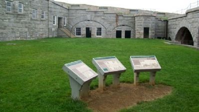
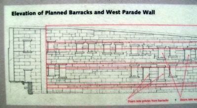
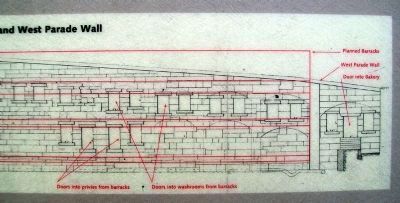
The major portion of the permanent living quarters inside the fort was not built. As planned, it would have been a long, three-story structure with a cellar, and stood directly across from you, over the area where the storage vaults in the parade ground are visible today.
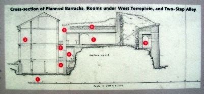
As described by Capt. Thomas Lincoln Casey in 1862, the planned barracks building would have had a kitchen on both the north and south ends and a space for laundresses to work in the attic. The soldiers' sleeping rooms would have been heated by stoves and had walls of painted, pressed brick. The barracks building would have been connected by walkways to the rooms that were built under the terreplein in the area across from you. The rooms on the bottom level had plumbing for privies. The upper rooms, located to the left of the bakery, were described by Capt. Casey as washrooms.
The number of soldiers that could have lived in these barracks is unknown. Generally, designs for forts like Fort Knox provided quarters for only a small standing army. Temporary quarters would have been added if more soldiers had been assigned to fully garrison the fort during a conflict.
Current historical research has not revealed why the barracks building was never built. Money was certainly scarce and had to be directed to completing as many cannon emplacements as possible. Further, the fort's engineers may have ultimately found more advantages in a permanent barracks building outside the fort's parade ground.
Cross-section of Planned Barracks, Rooms under West Terreplein, and Two-Step Alley
1. Storage vaults later built here
2. Planned barracks (not built)
3. Walkway connecting barracks and washrooms
4. Walkway connecting barracks and privies
5. West Parade Wall
6. Privy
7. Washroom
8. Terreplein (roof)
9. Two-Step Alley (Scarp Gallery)
Erected by Maine Department
of Conservation.
Topics. This historical marker is listed in these topic lists: Forts and Castles • War, Spanish-American • War, US Civil. A significant historical month for this entry is November 1865.
Location. 44° 33.965′ N, 68° 48.14′ W. Marker is in Prospect, Maine, in Waldo County. Marker is on the Parade Ground inside the fort, at Fort Knox State Historic Site. Touch for map. Marker is at or near this postal address: 711 Fort Knox Road (Maine Route 174), Stockton Springs ME 04981, United States of America. Touch for directions.
Other nearby markers. At least 8 other markers are within walking distance of this marker. The Heart of the Fort (here, next to this marker); Digging Down and Building Up (here, next to this marker); The Casemate - Key to Fort Design (a few steps from this marker); Firing a Cannon (a few steps from this marker); Fort Knox (within shouting distance of this marker); Terreplein (within shouting distance of this marker); A Grand Plan (within shouting distance of this marker); A Question of Boundaries (within shouting distance of this marker). Touch for a list and map of all markers in Prospect.
Also see . . .
1. Star fort at Wikipedia. (Submitted on May 9, 2012, by William Fischer, Jr. of Scranton, Pennsylvania.)
2. Fort Knox State Historic Site, Maine. (Submitted on May 9, 2012, by William Fischer, Jr. of Scranton, Pennsylvania.)
Credits. This page was last revised on September 23, 2020. It was originally submitted on May 9, 2012, by William Fischer, Jr. of Scranton, Pennsylvania. This page has been viewed 1,218 times since then and 29 times this year. Photos: 1, 2, 3, 4, 5. submitted on May 9, 2012, by William Fischer, Jr. of Scranton, Pennsylvania.
