Prospect in Waldo County, Maine — The American Northeast (New England)
Digging Down and Building Up
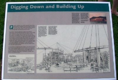
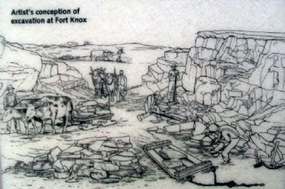
People, machines, and animals all played a part in the slow process of raising the walls that shaped Fort Knox. But before these walls could be built, people, machines, and animals also worked to prepare the site by earth, blasting ledge, and removing rocks and soil.
Isaac Stevens, the first engineer in charge of Fort Knox's construction, reported that rock excavation began on site in 1846 with a "full force" (more than 75 men and several ox and horse teams) worked four months. The next year, the work stopped due to lack of funds, but subsequently continued during several months of each year from 1848 through 1851. At the end of that period, more than 35,000 yards of stone (the equivalent of about 3,600 dump truck loads in today's terms) had been excavated and moved. Teams hauled most of the excavated stone (a dark brown bedrock, Penobscot schist) to the waterfront where it was used to build the "enrockment," a steep and massive rock-faced bank rising 75 feet between the river's edge and the site of the fort's main structure.
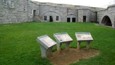
Because the fort was built from the outside to the inside, the walls that surround the parade ground were the last to be completed. These walls, with their soaring archways and beautiful stonework, are perhaps the best and final testament to the skills of the laborers, carpenters, stonecutters, blacksmiths, teamsters, and masons who built Fort Knox.
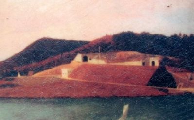
[Inset painting detail caption reads]
This detail of a painting most likely shows Fort Knox under construction during 1855 or 1856. The rock-faced bank (enrockment) from the river to the main level is complete by this time. To its right is the long, wooden inclined plane built in 1853 to transport granite from the wharf to the main fort site. The two arched openings shown seem to be part of the counterscarp gallery (Long Alley). In 1856, the fort's engineer in charge, Capt. John Kurtz, reported that the fort's front wall was about at the level of the casemate floors. The large mound shown is probably the rock that Kurtz described as being excavated for the cellar of the barracks.
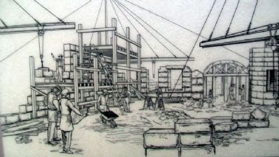
[Main drawing caption reads]
This conjectural drawing shows work on Fort Knox's north, east, and west parade ground walls in the spring of 1863. At this time, work on the fort was finally proceeding rapidly after years of little or no funding. The increased funds were the result of Maine's successful appeal to the federal government to complete the state's forts and ensure adequate defense of the coast and major rivers during the Civil War.
Fort Knox's April 1863 payroll report reflects the large force working on site including 6 carpenters, 2 engineers, 9 blacksmiths, 23 masons, 55 stone cutters,
4 teamsters, and 78 laborers. Of these workers, the master mason and master stonecutter received the highest pay at $3.00 per day; the laborers received the lowest at $.75 to $1.40 per day.
Erected by Maine Department of Conservation.
Topics. This historical marker is listed in these topic lists: Forts and Castles • War, US Civil. A significant historical year for this entry is 1846.
Location. 44° 33.965′ N, 68° 48.14′ W. Marker is in Prospect, Maine, in Waldo County. Marker is on the Parade Ground inside the fort, at Fort Knox State Historic Site. Touch for map. Marker is at or near this postal address: 711 Fort Knox Road (Maine Route 174), Stockton Springs ME 04981, United States of America. Touch for directions.
Other nearby markers. At least 8 other markers are within walking distance of this marker. Where Did the Soldiers Sleep? (here, next to this marker); The Heart of the Fort (here, next to this marker); The Casemate - Key to Fort Design (a few steps from this marker); Firing a Cannon (a few steps from this marker); Fort Knox (within shouting distance of this marker); Terreplein (within shouting distance of this marker); A Grand Plan (within shouting distance of this marker); A Question of Boundaries (within shouting distance of this marker). Touch for a list and map of all markers in Prospect.
Also see . . . Fort Knox State Historic Site, Maine. (Submitted on May 11, 2012, by William Fischer, Jr. of Scranton, Pennsylvania.)
Credits. This page was last revised on September 23, 2020. It was originally submitted on May 11, 2012, by William Fischer, Jr. of Scranton, Pennsylvania. This page has been viewed 528 times since then and 9 times this year. Photos: 1, 2, 3, 4, 5. submitted on May 11, 2012, by William Fischer, Jr. of Scranton, Pennsylvania.
