Near Hamilton in Hancock County, Illinois — The American Midwest (Great Lakes)
Thy Wondrous Story, Illinois
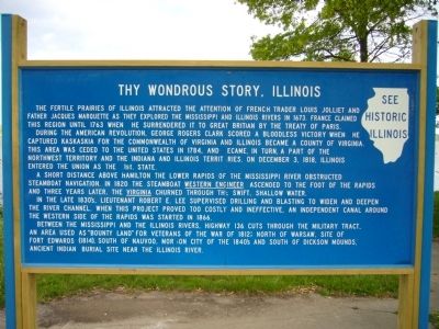
During the American Revolution, George Rogers Clark scored a bloodless victory when he captured Kaskaskia for the Commonwealth of Virginia and Illinois became a county of Virginia. This area was ceded to the United States in 1784, and became in turn a part of the Northwest Territory and the Indiana and Illinois Territories. On December 3, 1818, Illinois entered the Union as the 21st state.
A short distance above Hamilton the lower rapids of the Mississippi River obstructed steamboat navigation. In 1820 the steamboat Western Engineer ascended to the foot of the rapids and three years later, the Virginia churned through the swift, shallow water.
In the late 1830's, Lieutenant Robert E. Lee supervised drilling and blasting to widen and deepen the river channel. When this project proved too costly and ineffective, an independent canal around the western side of the rapids was started in 1866.
Between the Mississippi and the Illinois Rivers, Highway 136 cuts through the military tract, an area used as “Bounty Land” for veterans of the War of 1812; north of Warsaw, site of Fort Edwards (1814), south of Nauvoo, Mormon City of the 1840's and south of Dickson Mounds, ancient Indian burial site near the Illinois River.
Topics and series. This historical marker is listed in these topic lists: Exploration • Settlements & Settlers. In addition, it is included in the Illinois State Historical Society series list. A significant historical month for this entry is December 1857.
Location. 40° 26.978′ N, 91° 22.203′ W. Marker is near Hamilton, Illinois, in Hancock County. Marker is on Illinois Route 96 at milepost 20,, 0.1 miles south of County Road 1720, on the left when traveling north. Marker is located at roadside pull out along the Mississippi River. Touch for map. Marker is in this post office area: Hamilton IL 62341, United States of America. Touch for directions.
Other nearby markers. At least 8 other markers are within 4 miles of this marker, measured as the crow flies. Montebello (approx. 1.6 miles away); U.S.S Maine Memorial (approx. 2.6 miles away in Iowa); U.S.S. Maine Memorial (approx. 2.6 miles away in Iowa); To The Memory of Pioneers (approx. 2.7 miles away in Iowa); Keokuk Memorial (approx. 2.7 miles away in Iowa); Keokuk's Speech In 1812 (approx. 2.7 miles away in Iowa); Keokuk Armory Explosion Memorial (approx. 2.8 miles away in Iowa); Hugh Lincoln Cooper (approx. 3.4 miles away in Iowa).
Credits. This page was last revised on June 16, 2016. It was originally submitted on May 16, 2012, by Bill Kirchner of Tucson, Arizona. This page has been viewed 561 times since then and 21 times this year. Photos: 1, 2. submitted on May 16, 2012, by Bill Kirchner of Tucson, Arizona. • Bernard Fisher was the editor who published this page.

