Near Halls in Lauderdale County, Tennessee — The American South (East South Central)
Dyer County / Lauderdale County
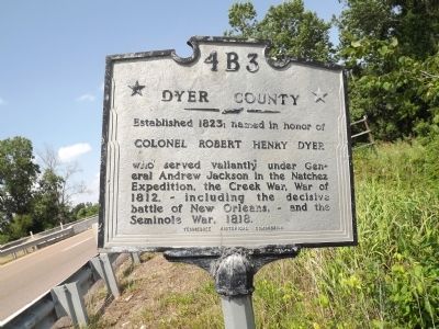
Dyer County
Established 1823; named in honor of
Colonel Robert Henry Dyer
who served valiantly under General Andrew Jackson in the Natchez Expedition, the Creek War, War of 1812, - including the decisive battle of New Orleans, - and the Seminole War, 1818.
(reverse)
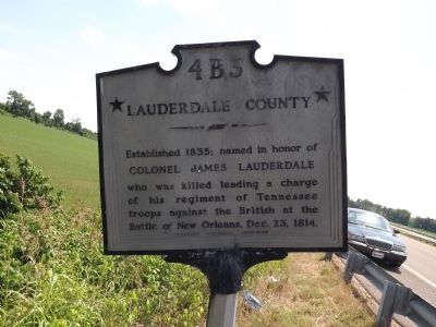
Lauderdale County
Established 1835; named in honor of
Colonel James Lauderdale
who was killed leading a charge of his regiment of Tennessee troops against the British at the Battle of New Orleans, Dec. 23, 1814.
Erected by Tennessee Historical Commission. (Marker Number 4B3.)
Topics and series. This historical marker is listed in these topic lists: Settlements & Settlers • War of 1812 • Wars, US Indian. In addition, it is included in the Former U.S. Presidents: #07 Andrew Jackson, and the Tennessee Historical Commission series lists. A significant historical date for this entry is December 23, 1941.
Location. 35° 56.832′ N, 89° 24.512′ W. Marker is near Halls, Tennessee, in Lauderdale County. Marker is on Jefferson Davis Highway (U.S. 51) south of Unionville Road / Old Hwy 20 (Tennessee Route 210), on the right when traveling north. Touch for map . Marker is in this post office area: Halls TN 38040, United States of America. Touch for directions.
Other nearby markers. At least 8 other markers are within 6 miles of this marker, measured as the crow flies. Key Corner (approx. 2.1 miles away); Dyersburg Army Airfield (approx. 3.2 miles away); Mrs. Rosa M. Parks (approx. 4.1 miles away); Roark Bradford (approx. 4.6 miles away); William Nash (approx. 5 miles away); First Three Phase Padmount Transformer (approx. 6 miles away); Dyer County WWII Memorial (approx. 6 miles away); Dyer County Walk of Fame (approx. 6 miles away). Touch for a list and map of all markers in Halls.
Credits. This page was last revised on June 16, 2016. It was originally submitted on June 3, 2012, by Ken Smith of Milan, Tennessee. This page has been viewed 664 times since then and 26 times this year. Last updated on June 3, 2012, by Ken Smith of Milan, Tennessee. Photos: 1, 2, 3. submitted on June 3, 2012, by Ken Smith of Milan, Tennessee. • Craig Swain was the editor who published this page.


