Frying Pan Baptist Church and Cemetery near Herndon in Fairfax County, Virginia — The American South (Mid-Atlantic)
Frying Pan Meeting House
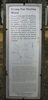
Frying Pan Springs Meeting House was erected c. 1791 on land granted by Robert “Counsellor” Carter to a group of “Old School” Baptists. In addition to local farmers the fundamentalist beliefs of its members also attracted free blacks and slaves to the congregation. From the beginning blacks were listed as members, baptized in the springs behind the meeting house and interred in the adjacent burial grounds.
In the post-Revolutionary period, Baptists were among the first to establish themselves apart from the Episcopal Church which had dominated religious life in colonial Virginia. Even in its wood construction this meeting house represented a symbolic break from traditional brick Episcopal churches. The simple materials and plain style were in keeping with the conservative doctrine of the congregation. Largely unaltered, this structure provides one of the few remaining local examples of 18th century vernacular church architecture.
The meeting house served as a landmark upon the rural landscape of western Fairfax County from the 1790s into the mid-20th century. The last surviving member of the declining congregation deeded the meeting house and its adjoining springs, baptismal pond, grounds and cemetery to the Fairfax County Park Authority in 1984.
Erected by Fairfax County Park Authority, Division of Historic Preservation.
Topics. This historical marker is listed in these topic lists: African Americans • Churches & Religion. A significant historical year for this entry is 1791.
Location. 38° 56.39′ N, 77° 24.783′ W. Marker is near Herndon, Virginia, in Fairfax County. It is in Frying Pan Baptist Church and Cemetery. Marker is at the intersection of Centerville Road (County Route 657) and Frying Pan Road (Virginia Route 608), on the right when traveling north on Centerville Road. Located in Frying Pan Park, of Fairfax County Parks System. Touch for map. Marker is in this post office area: Herndon VA 20171, United States of America. Touch for directions.
Other nearby markers. At least 8 other markers are within walking distance of this marker. A different marker also named Frying Pan Meeting House (a few steps from this marker); Pin Oak (a few steps from this marker); Civil War at Frying Pan Spring Meeting House (a few steps from this marker); a different marker also named Frying Pan Meeting House (a few steps from this marker); The 4-H Building (approx. 0.2 miles away); The Moffett Family Blacksmith Shop (approx. ¼ mile away); Middleton Barn (approx. 0.3 miles away); The Smokehouse / Curing and Smoking Meat (approx. 0.3 miles away). Touch for a list and map of all markers in Herndon.
More about this marker. To visit this site, plan to stop at the main parking lot off West Ox Road (VA Route 608) and use one of the walking trails to get to the meeting house. There is limited pull off space next to the marker, and depending on the time of day, Centerville Road can be dangerous to cross.
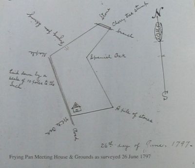
The marker has a rendition of a map of the area with the caption, “Frying Pan Meeting House & Grounds as surveyed 26 June 1797.”
Credits. This page was last revised on September 21, 2023. It was originally submitted on August 27, 2007, by Craig Swain of Leesburg, Virginia. This page has been viewed 1,458 times since then and 34 times this year. Last updated on February 22, 2008, by Christopher Busta-Peck of Shaker Heights, Ohio. Photos: 1, 2. submitted on August 27, 2007, by Craig Swain of Leesburg, Virginia.

