Plymouth in Washington County, North Carolina — The American South (South Atlantic)
Battle of Plymouth
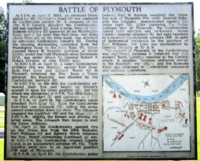
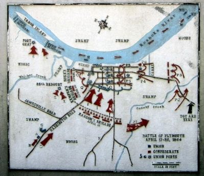
At 4 P.M. on April 17, 1864, an advanced Union patrol on the Washington Road (A) was captured by Confederate cavalry (B). A company of the 12th N.Y. Cavalry attacked the Confederates, but was repulsed (C). Soon a large force of Confederate infantry (D) appeared on the Washington Road, and at the same time Fort Gray, two miles above Plymouth on the river bank, was attacked by advanced Confederate infantry (E). During the evening skirmishing continued from the Washington Road to the Acre Road (F). Union General Henry W. Wessells’ garrison of about 3,000, which had held Plymouth since December, 1862, was under attack by General Robert F. Hoke’s Division of over 5,000 men.
At 5:30 A.M. on April 18, a heavy Confederate artillery fire was directed against Fort Gray. Both Fort Gray and Battery Worth (G) in Plymouth returned the fire. Soon a Union gunboat, the Bombshell, was disabled by the Confederate barrage (H).
At 6:30 P.M. on the 18th the Confederates advanced their line and began an infantry assault (I) upon the Union position (J); but this attack was abandoned at 8 P.M. The 85th Redoubt was then attacked (K) and captured at 11 P.M.
At 3 A.M. on April 19, the Confederates again attacked Fort Gray (L). Soon the Confederate iron-clad ram Albemarle (M), aiding the army, passed undetected down the river. The Albemarle engaged the Southfield (N1) and the Miami (N2) at 3:30 A.M., sinking the former and driving the latter away. The Albemarle then began to shell the Union defenses.
On April 19 the Confederates opened fire on the Union line from the 85th Redoubt. Fort Williams (O) and Battery Worth returned the fire. Heavy skirmishing continued all day. At 6:30 P.M. the Confederates crossed Coneby Creek in an unexpected advance (P1, P2). Their infantry were now in an important position (P3) east of Plymouth.
At 5 A.M. on April 20, the Confederates under General Matt W. Ransom assaulted the Union line east of Plymouth (P4), while General Hoke, with two brigades, demonstrated against the Union right (Q). After capturing the Union defenses east of Plymouth, the Confederates halted their advance and re-formed. Union infantry counter-attacked (R), but were repulsed by a renewed Confederate advance (P5). In spite of determined resistance by the garrison of Fort Williams, the town was surrendered by General Wessells at 10 A.M.
The capture of Plymouth by the Confederates was significant because it returned two rich eastern North Carolina counties to the Confederacy; it supplied “immense ordnance stores” to the Southern war effort; and the Roanoke River was reopened to Confederate commerce and military operations.
Erected 1962 by Archives and Highway Department. (Marker Number BB-6.)
Topics and series. This historical marker is listed in this topic list: War, US Civil. In addition, it is included in the North Carolina Division of Archives and History series list. A significant historical month for this entry is April 1862.
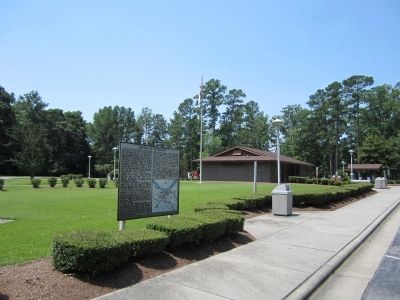
Location. 35° 51.908′ N, 76° 43.532′ W. Marker is in Plymouth, North Carolina, in Washington County. Marker can be reached from U.S. 64 west of East Main Street, on the left when traveling west. Located in the Plymouth rest area. Touch for map. Marker is in this post office area: Plymouth NC 27962, United States of America. Touch for directions.
Other nearby markers. At least 8 other markers are within 2 miles of this marker, measured as the crow flies. Naval Action (approx. 0.8 miles away); Fort Compher Battlefield (approx. one mile away); Battle of Plymouth Memorial (approx. one mile away); Carthagenia Lodge (approx. 1.2 miles away); Plymouth State Normal School (approx. 1.2 miles away); New Chapel Baptist Church (approx. 1.2 miles away); Latham House (approx. 1.2 miles away); Union Earthworks (approx. 1.3 miles away). Touch for a list and map of all markers in Plymouth.
Credits. This page was last revised on July 2, 2021. It was originally submitted on June 30, 2012, by Bernard Fisher of Richmond, Virginia. This page has been viewed 854 times since then and 36 times this year. Photos: 1, 2, 3. submitted on June 30, 2012, by Bernard Fisher of Richmond, Virginia.


