San Juan Bautista in San Benito County, California — The American West (Pacific Coastal)
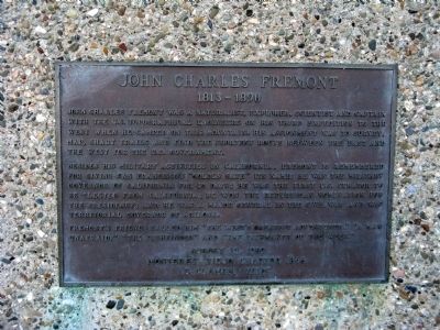
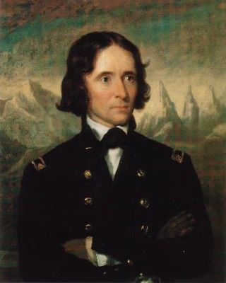
John Charles Fremont
1813 – 1890
John Charles Fremont was a naturalist, explorer, scientist and Captain with the U.S. Topographical Engineers on his third expedition to the West when he camped on this mountain. His assignment was to survey, map, chart trails and find the shortest route between the East and the West for the U.S. Government.
Besides his military activities in California, Fremont is remembered for giving San Francisco’s “Golden Gate” its name; he was the military Governor of California for 50 days; he won the Republican nomination for the Presidency; and he was a Major General in the Civil War and was Territorial Governor of Arizona.
Fremont’s friends called him “the west’s greatest adventurer,” “a man unafraid,” “The Pathfinder” and “The Pathmaker of the West.”
Erected 1989 by Monterey Viejo Chapter No.1846, E. Clampus Vitus. (Marker Number 181.)
Topics and series. This historical marker is listed in these topic lists: Exploration • Notable Places • Settlements & Settlers. In addition, it is included in the California Historical Landmarks, and the E Clampus Vitus series lists.
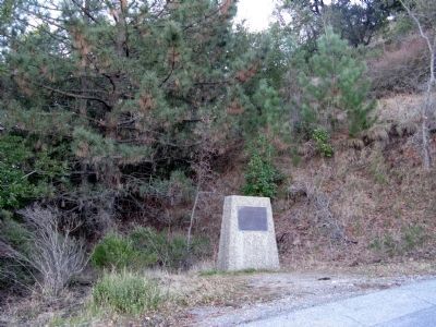
Location. 36° 45.536′ N, 121° 30.206′ W. Marker is in San Juan Bautista, California, in San Benito County. Marker can be reached from San Juan Canyon Road. Marker is located at the Fremont Peak Trail Head, Fremont Peak State Park, 11 miles south of San Juan Bautista. Touch for map. Marker is in this post office area: San Juan Bautista CA 95045, United States of America. Touch for directions.
Other nearby markers. At least 8 other markers are within 7 miles of this marker, measured as the crow flies. Fremont Peak (a few steps from this marker); Fremont Peak Memorial (about 700 feet away, measured in a direct line); A Changing World (approx. 5.3 miles away); Natividad (approx. 5½ miles away); Battle of Natividad (approx. 5.6 miles away); San Juan Pacific Railway (approx. 5.8 miles away); Vineyard School (approx. 5.9 miles away); Anza House (approx. 6.1 miles away). Touch for a list and map of all markers in San Juan Bautista.
Regarding John Charles Fremont. This site was designated as California Registered Historical Landmark No.181 on March 6, 1935.
Statement of Significance:
On March 6, 1846, Captain John C. Frémont built a fort here on Gabilan (Gavilan) Peak (Fremont Peak). He unfurled his colors and for four days awaited the attack of a force of Californians. The battle did not materialize by the night of March 9, and Frémont broke camp and departed for Oregon.
Also see . . .
1. John C. Fremont. Wikipedia entry (Submitted on September 3, 2021, by Larry Gertner of New York, New York.)
2. Fremont Peak State Park. California Department of Parks and Recreation website entry (Submitted on January 15, 2009.)
3. Captain John Charles Fremont and the Bear Flag Revolt. The California Military Museum website entry (Submitted on January 15, 2009.)
Additional commentary.
1. Why is this called Fremont Peak?
In 1846, while California was still a part of Mexico, Army Captain John C. Fremont of the Topographical Engineers led an expeditionary force into the Salinas Valley and to the top of Gavilan Peak. Ostensibly, they were there to explore and survey the area, but the group was clearly an armed force. The peak was a strategic location – Fremont could see anyone for miles. Long suspicious of Fremont’s motives, Mexican Commandante General Jose Castro ordered him to leave California immediately. In defiance, Fremont hastily built a log stockade at the peak and raised the U.S. Military Flag. However, U.S. Consul Thomas O. Larkin in Monterey sent Fremont a hand delivered letter telling him that he had to obey Castro’s orders to leave. In the middle of a windy night, after his flag had blown over, Fremont gathered his troops and abandoned Gavilan Peak.
During the Mexican-American War, Fremont led the California Battalion, but in 1847 U.S. General Stephen W. Kearny censured him for his “conduct in California”. Fremont was arrested, court-martialed and found guilty of mutiny, disobedience and conduct to the prejudice of good order and military discipline. President James K. Polk later removed the charge of mutiny, and Fremont became a U.S. Senator representing California’s Mariposa area. In 1856, he ran unsuccessfully for president.
Source: Fremont Peak State Park Brochure
— Submitted January 15, 2009, by Syd Whittle of Mesa, Arizona.
2. The Gavilan Peak Affair
John C. Fremont and his company of U.S. "surveyors" had been allowed to winter in California provided they stayed away from the coastal settlements. In March 1846 they suddenly appeared in the hills near Monterey. Commondante Castro notified Fremont that he would have to leave California, but Fremont ignored the demand and led his men to the summit of Gavilan Peak, now known as Fremont Peak, overlooking San Juan. After three days, following an exchange of diplomatic (and some not-so-diplomatic) messages, Fremont decided to comply and withdrew, "slowly and growlingly" as he later described it.
On July 7, 1846, after the outbreak of war between Mexico and the U.S., Commodore Sloat landed his troops at Monterey and claimed California for the United States. In November of that year, Fremont returned to San Juan Bautista as a lieutenant colonel in the U.S. Army and spent nearly two weeks gathering horses, mules and supplies for his 428-man army. Known as the California Battalion, Fremont's army left San Juan on November 28, 1846. Despite considerable hardship, they met with Andres Pico to sign the Treaty of Cahuenga, ending the armed hostilities between the U.S. and Mexico.
Source: San Juan Bautista State Park Brochure
— Submitted January 16, 2009, by Syd Whittle of Mesa, Arizona.
Credits. This page was last revised on September 3, 2021. It was originally submitted on January 15, 2009, by Syd Whittle of Mesa, Arizona. This page has been viewed 3,265 times since then and 46 times this year. Last updated on July 30, 2012, by Michael Kindig of Elk Grove, California. Photos: 1, 2, 3, 4, 5. submitted on January 15, 2009, by Syd Whittle of Mesa, Arizona.
