North Omaha in Douglas County, Nebraska — The American Midwest (Upper Plains)
Ordnance Magazine
Fort Omaha Walking Tour
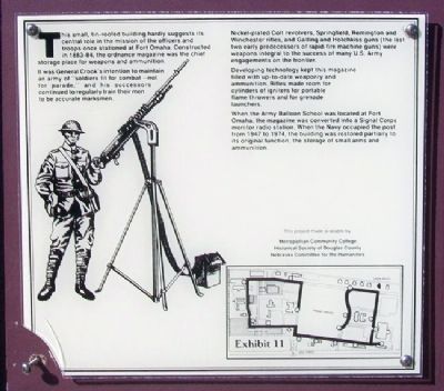
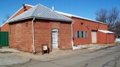
This small, tin-roofed building hardly suggests its central role in the mission of the officers and troops once stationed at Fort Omaha. Constructed in 1883-84, the ordnance magazine was the chief storage place for weapons and ammunition.
It was General Crook’s intention to maintain an army of “soldiers fit for combat – not for parade,” and his successors continued to regularly train their men to be accurate marksmen.
Nickel-plated Colt revolvers, Springfield, Remington and Winchester rifles, and Gatling and Hotchkiss guns (the last two early predecessors of rapid-fire machine guns) were weapons integral to the success of many U.S. Army engagements on the frontier.
Developing technology kept this magazine filled with up-to-date weaponry and ammunition. Rifles made room for cylinders of igniters for portable flame throwers and for grenade launchers.
When the Army Balloon School was located at Fort Omaha, the magazine was converted into a Signal Corps monitor radio station. When the Navy occupied the post from 1947 to 1974, the building was restored partially to its original function, the storage of small arms and ammunition.
Erected by Metropolitan Community College, Historical Society of Douglas County, and Nebraska Committee for the Humanities. (Marker Number 11.)
Topics. This historical marker is listed in these topic lists: Forts and Castles • War, World I • War, World II. A significant historical year for this entry is 1947.
Location. 41° 18.333′ N, 95° 57.488′ W. Marker is in Omaha, Nebraska, in Douglas County. It is in North Omaha. Marker is on the Alley between 2nd and 1st Roads, on the left when traveling north. Marker is southeast of Building 26, on the Metropolitan Community College Campus. Touch for map. Marker is in this post office area: Omaha NE 68111, United States of America. Touch for directions.
Other nearby markers. At least 8 other markers are within walking distance of this marker. Fort Omaha Headquarters Building (about 500 feet away, measured in a direct line); Fort Omaha Fire Station (about 500 feet away); Fort Omaha (about 600 feet away); Fort Omaha Quartermaster Depot (about 700 feet away); Fort Omaha Post Exchange and Gymnasium (about 700 feet away); Fort Omaha Hospital (approx. 0.2 miles away); Fort Omaha Guardhouse (approx. 0.2 miles away); History of Fort Omaha (approx. 0.2 miles away). Touch for a list and map of all markers in Omaha.
Also see . . . Fort Omaha. (Submitted on August 6, 2012, by William Fischer, Jr. of Scranton, Pennsylvania.)
Credits. This page was last revised on February 16, 2023. It was originally submitted on August 6, 2012, by William Fischer, Jr. of Scranton, Pennsylvania. This page has been viewed 616 times since then and 18 times this year. Photos: 1, 2. submitted on August 6, 2012, by William Fischer, Jr. of Scranton, Pennsylvania.

