Cheat Bridge in Randolph County, West Virginia — The American South (Appalachia)
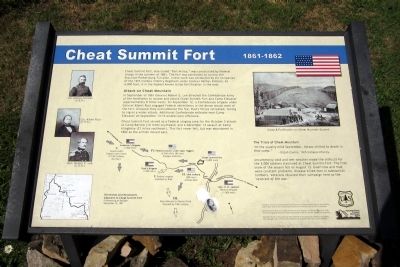
Cheat Summit Fort
1861-1862
Attack on Cheat Mountain
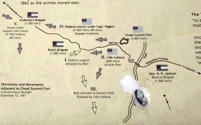
In September of 1861 of General Robert E. Lee directed the Confederate Army of the Northwest to isolate and attack Cheat Summit Fort and Camp Elkwater (approximately 8 miles west). On September 12, a Confederate brigade under Colonel Albert Rust engaged Federal skirmishers in the dense woods west of the fort. Unaware they outnumbered the foe, Rust’s forces retreated, falling to signal a wider attack. Additional Confederate setbacks near Camp Elkwater on September 13-14 ended Lee’s offensive.
Cheat Summit Fort served as a Federal staging area for the October 3 attack at Camp Bartow (12 miles southeast) and a December 13 assault at Camp Allegheny (21 miles southeast). This fort never fell, but was abandoned in 1862 as the armies moved east.
The Trials of Cheat Mountain
“In the usually mild September, horses chilled to death in that camp.” - Elijah Cavins, 14th Indiana Infantry
Uncommonly cold and wet weather made life difficult for the 3,000 soldiers stationed at Cheat Summit Fort. The first snow of the season fell on August 13. Guerrillas and mud were constant problems. Disease killed men in substantial numbers. Veterans recalled their campaign here as the “severest of the war.”
Artifacts, structures, and archaeological resources at Cheat Summit Fort are protected by federal laws such as the Archaeological Resources Protection Act of 1979, as amended.
Cheat Summit Fort was added to the National Register of Historic Places in 1990. The Monongahela National Forest administers the fort for the benefit of the public.
Caution: Much of this area has been altered by strip-mining. Please avoid going near all high walls. These embankments are unpredictable and could collapse.
Erected by US Forest Service.
Topics. This historical marker is listed in these topic lists: Forts and Castles • War, US Civil. A significant historical month for this entry is September 1861.
Location. 38° 37.309′ N, 79° 52.841′ W. Marker is in Cheat Bridge, West Virginia, in Randolph County. Marker is on County Route 250/4, 1.1 miles west of U.S. 250, on the right when traveling west. Touch for map. Marker is in this post office area: Huttonsville WV 26273, United States of America. Touch for directions.
Other nearby markers. At least 8 other markers are within 3 miles of this marker, measured as the crow flies. Behind the Parapet (about 400 feet away, measured in a direct line); Guarding the Turnpike (about 500 feet away); Astride the Road from Nowhere (about 500 feet away); Cabin Remains (about 600 feet away); Shavers Fork (approx. 0.8 miles away); Cheat Summit Camp (approx. one mile away); Asa Gray / Buffalo-Indian Trail (approx. one mile away); Cheat Mountain (approx. 2.4 miles away). Touch for a list and map of all markers in Cheat Bridge.
More about this marker. On the left are portraits of "Col. Nathan Kimball (U.S.A.)", "Col. Albert Rust (C.S.A.)" and "Gen. Robert E. Lee (C.S.A.)"
On the right is a sketch of "Camp & Fortifications on Cheat Mountain Summit"
Credits. This page was last revised on June 16, 2016. It was originally submitted on August 10, 2012, by Bernard Fisher of Richmond, Virginia. This page has been viewed 1,596 times since then and 50 times this year. Photos: 1, 2, 3. submitted on August 10, 2012, by Bernard Fisher of Richmond, Virginia.


