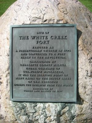
Salem in Washington County, New York — The American Northeast (Mid-Atlantic)
The White Creek Fort
Topics. This historical marker is listed in this topic list: War, US Revolutionary. A significant historical year for this entry is 1774.
Location. 43° 10.355′ N, 73° 19.58′ W. Marker is in Salem, New York, in Washington County. Marker is at the intersection of County Route 153 and New York State Route 22, on the left when traveling east on County Route 153. The marker is located next to the Fort Theatre. Touch for map. Marker is at or near this postal address: 18- 22 East Broadway, Salem NY 12865, United States of America. Touch for directions.
Other nearby markers. At least 8 other markers are within 3 miles of this marker, measured as the crow flies. T/SGT Francis J. Clark (about 400 feet away, measured in a direct line); Old White Church (about 700 feet away); 1852 Rail Yard (about 800 feet away); General John Williams (approx. 0.2 miles away); Stockaded Fort (approx. 0.2 miles away); Lest We Forget (approx. 0.2 miles away); Revolutionary Cemetery (approx. 0.4 miles away); Rexleigh Covered Bridge (approx. 3 miles away). Touch for a list and map of all markers in Salem.
Additional keywords. Burgoyne Campaign, 1777
Credits. This page was last revised on June 16, 2016. It was originally submitted on August 17, 2012, by Tom McGreevy of Averill Park, New York. This page has been viewed 443 times since then and 21 times this year. Photo 1. submitted on August 17, 2012, by Tom McGreevy of Averill Park, New York. • Bill Pfingsten was the editor who published this page.
