Lookout Mountain in Hamilton County, Tennessee — The American South (East South Central)
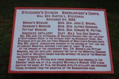
Stevenson's Division
Breckinridge's Corps.
— Maj. Gen. Carter L. Stevenson. —
Maj. Gen. Carter L. Stevenson.
Nov. 24, 1863
Brown's Brigade - Brig. Gen. John C. Brown.
Cumming's Brigade - Brig. Gen. Alfred Cumming.
Pettus' Brigade - Brig. Gen. Edmund W. Pettus.
Cherokee Artillery - Capt. Max Van Den Corput.
Nov. 23d, upon the withdrawal of Walker's Division from the line west of Chattanooga Creek to the extreme right on Missionary Ridge, Gen. Stevenson with his own and three Brigades of Cheatham's Division under Brig. Gen. John K. Jackson was assigned to the defense of that line and of Lookout Mountain, covering a distance of about 15 miles.
At the opening of the engagement Nov. 24, Brown's and Pettus' Brigades and the artillery, occupied the top of the Mountain; Cumming held part of Walker's former position between the base of the Mountain and Chattanooga Creek.
About 12:30 P.M. Pettus with three regiments was ordered to the Cravens' House and at 1 P.M. relieved Walthall's Brigade 400 yards south of the house. At 7 P.M. the Division with its artillery and ordnance trains withdrew from the mountain by the Summertown Road.
Erected 1890 by the Chickamauga-Chattanooga National Battlefield Commission. (Marker Number MT-359.)
Topics and series. This historical marker is listed in this topic list: War, US Civil. In addition, it is included in the Chickamauga and Chattanooga National Military Park, Point Park, and the Chickamauga and Chattanooga National Military Park: November 24, 1863 series lists. A significant historical month for this entry is October 1805.
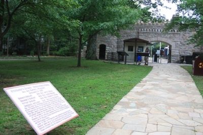
Location. 35° 0.61′ N, 85° 20.626′ W. Marker is in Lookout Mountain, Tennessee, in Hamilton County. Marker can be reached from Point Park Road north of East Brow Road. This historic marker is located in Point Park, along the pathway that runs due north from the entrance to Point Park, to the cluster of markers and cannons that are due north at the mountain's "overlook." The marker is about a third of the way north, on the right hand (east) side of the pathway. Touch for map. Marker is in this post office area: Lookout Mountain TN 37350, United States of America. Touch for directions.
Other nearby markers. At least 8 other markers are within walking distance of this marker. Point Park (a few steps from this marker); The Battles for Chattanooga (a few steps from this marker); Occupation of the Summit of Lookout (within shouting distance of this marker); Union Casualties (within shouting distance of this marker); 96th Illinois Infantry (within
shouting distance of this marker); Corput's Georgia Battery (within shouting distance of this marker); Confederate Casualties (within shouting distance of this marker); Confederate Forces – Battle of Lookout (within shouting distance of this marker). Touch for a list and map of all markers in Lookout Mountain.
Related markers. Click here for a list of markers that are related to this marker. Use this link to see the Brigade and Battery tablets for this Division.
Credits. This page was last revised on May 10, 2017. It was originally submitted on August 26, 2012, by Dale K. Benington of Toledo, Ohio. This page has been viewed 551 times since then and 17 times this year. Photos: 1, 2, 3. submitted on August 27, 2012, by Dale K. Benington of Toledo, Ohio.


