Columbus in Cherokee County, Kansas — The American Midwest (Upper Plains)
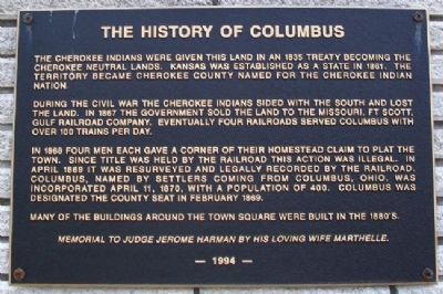
The History of Columbus
The Cherokee Indians were given this land in an 1835 treaty becoming the Cherokee Neutral Lands. Kansas was established as a state in 1861. The territory became Cherokee County named for the Cherokee Indian Nation.
During the Civil War the Cherokee Indians sided with the South and lost the land. In 1867 the government sold the land to the Missouri, Ft Scott, [&] Gulf Railroad Company. Eventually four railroads served Columbus with over 100 trains per day.
In 1868 four men each gave a corner of their homestead claim to plat the town. Since title was held by the railroad this action was illegal. In April 1869 it was resurveyed and legally recorded by the railroad. Columbus, named by settlers coming from Columbus, Ohio, was incorporated April 11, 1870, with a population of 400. Columbus was designated the county seat in February 1869.
Many of the buildings around the town square were built in the 1880's.
Memorial to Judge Jerome Harman by his loving wife Marthelle.
Erected 1994.
Topics. This historical marker is listed in these topic lists: Native Americans • Railroads & Streetcars • Settlements & Settlers. A significant historical month for this entry is February 1869.
Location. 37° 10.657′ N, 94° 49.852′ W. Marker is in Columbus, Kansas, in Cherokee County. Marker is at the intersection of U.S. 69/160 and North East Avenue (U.S. 69), on the right when traveling east on U.S. 69/160. Touch for map. Marker is at or near this postal address: 612 North East Avenue, Columbus KS 66725, United States of America. Touch for directions.
Other nearby markers. At least 8 other markers are within 9 miles of this marker, measured as the crow flies. Three-Way Interlocking Crossing (approx. 0.7 miles away); Robert Alexander Long (approx. ¾ mile away); Columbus State Bank 100th Anniversary (approx. 0.8 miles away); Cherokee County WWI Veterans Memorial Clock Tower (approx. 0.8 miles away); 1932 Plymouth 0-6-0 Switch Engine (approx. 7.2 miles away); Southern Pacific Bay Window Caboose (approx. 7.2 miles away); Missouri Pacific Wooden Frame Depot (approx. 7.2 miles away); Marsh Rainbow Arch Bridge (approx. 8.7 miles away). Touch for a list and map of all markers in Columbus.
Also see . . .
1. History of Cherokee County, Kansas, in Cutler's History (1883). (Submitted on November 1, 2012, by William Fischer, Jr. of Scranton, Pennsylvania.)
2. History of Cherokee County, Kansas (1904). "Kansas History" website (Submitted on November 1, 2012, by William Fischer, Jr. of Scranton, Pennsylvania.)
3. City of Columbus, Kansas, Official Website. (Submitted on November 1, 2012, by William Fischer, Jr. of Scranton, Pennsylvania.)
Credits. This page was last revised on November 28, 2020. It was originally submitted on November 1, 2012, by William Fischer, Jr. of Scranton, Pennsylvania. This page has been viewed 444 times since then and 30 times this year. Photos: 1, 2. submitted on November 1, 2012, by William Fischer, Jr. of Scranton, Pennsylvania.

