Big Spring
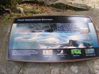
Ozark National Scenic Riverways
— National Park Service-U.S.Department of the Interior —
Springs are unique and specialized habitats, primarily due to cool temperatures and flowing water. Many species found in Big Spring prefer springs over other aquatic habitats.
Aquatic Snail • Mayfly • Watercress • Water Buttercups
Topics. This historical marker is listed in this topic list: Natural Features.
Location. 36° 57.168′ N, 90° 59.532′ W. Marker is in Van Buren, Missouri, in Carter County. Marker is on Pea Vine Road. Touch for map. Marker is in this post office area: Van Buren MO 63965, United States of America. Touch for directions.
Other nearby markers. At least 7 other markers are within 4 miles of this marker, measured as the crow flies. Big Spring: A Karst Topography (within shouting distance of this marker); Building Human Happiness (approx. 0.3 miles away); There Was Work To Be Done (approx. 0.3 miles away); Camp Hains - 1710 (approx. 0.3 miles away); CCC - A Peace-Time Army (approx. 0.3 miles away); Van Buren (approx. 3.2 miles away); Carter County Veterans Memorial (approx. 3.2 miles away).
Credits. This page was last revised on June 16, 2016. It was originally submitted on December 10, 2012, by Don Morfe of Baltimore, Maryland. This page has been viewed 517 times since then and 38 times this year. Photos: 1, 2, 3, 4. submitted on December 10, 2012, by Don Morfe of Baltimore, Maryland. • Bill Pfingsten was the editor who published this page.


