Bonnieux in Vaucluse, Provence-Alps-French Riviera, France — Western Europe
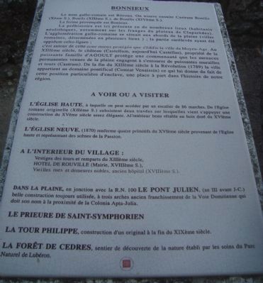
Bonnieux
Le nom gallo-romain est Bitrona. On trouve ensuite Castrum Bonilis (Xeme S.) Bonils (XIIeme S.) de Bonilis (XIVeme S.).
La forme provençale est Bonieux
La préhistoire est ici présente en de nombreux lieux (habitants néolithiques, notamment sur les franges du plateau de Claparedes). L’agglomération gallo-romaine se situait aux abords de la plaine (villas romaines, déterminées en plusieurs lieux): la partie surélevée ayant été oppidum celto-ligure;
c’est autour de cette zone mieux protégée que s’édifie la ville du Moyen-Age. Au XIIIeme siècle, le château (Castellum, aujourd’hui Castellas), propriété de la puissante famille d’Agoult protège une communauté que les menaces permanentes venues de la plaine engagent à s’entourer de puissanrtes murailles en tours (Castrum). De la fin du XIIIeme siècle à la Révolution (1789) la ville appartient au domaine pontifical (Comtat Venaissin) ce qui lui donne du fait de cette position particulière d’enclave, une place à part dans l’histoire de notre région.
A Voir Ou A Visiter
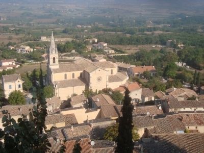
L’eglise Haute, à laquelle an peut accéder par un escalier de 86 marches. De l’Eglise romane originelle (XIIeme S.) subsistent duex travées sur lesquelles vient s’appuyer une construction du XVem siècle assez élégante. Al’intérieur beau rétable en bois doré du XVeme siècle.
L’eglise Neuve, (1879) renferme quatre primitifs du XVIeme siècle provenant de l’Eglise haute en représentant des scènes de la Passion. A l’interieur du village:
Vesitiges des tours et remparts du XIIIeme siecle.
Hotel de Rouville (Mairie, XVIIIeme S.).
Vieilles rues et demeures nobles, ancien hôspital (XVIIIeme S.).
Dans la plaine, en junction avec la R.N. 100 Le Pont julien, (an III avant J.C.) belle construction tourjours utilisée, à trois arches ancien franchissement de la Voie Domitoemme qui doit son nom à la proximité de la Colonia Apta-Julia.
Le Prieure de Saint-Symphorien
La Tour Philippe, construction d’un original à la fin du XIXeme siècle.
La Forêt de Cedres, sentier de découverte de la nature établi par les soins du Parc Naturel de Lubéron.
(Translated by Google Translate with modifications:)
Bonnieux
The Gallo-Roman name was Bitrona. Then it was Bonilis Castrum (Xth century) Bonils (XIIth century) of Bonilis (S. XIV).
The Provencal form is Bonieux Prehistory is present here in many places (Neolithic settlers, especially on the fringes of the plateau Claparedes). The Gallo-Roman town stood on the edge of the plain (Roman villas were located in several places): the raised part was oppidum Celto-Liguria; it is around this area better protected than the town is built in the Middle Ages. In the XIII century, the castle (Castellum today Castellas), owned by the powerful family from Agout, in order to protect the community from continuing threats coming from the plain, undertook to surround himself with powerful walls and towers (Castrum). From the end of the XIII century to the Revolution (1789) the city belongs to the papal domain (Papal) which gives a result of this particular position enclave, a place in the history of our region.
To See or to Visit
The High Church, which can be accessed by a stairs of 86 steps. The original Romanesque church (XIIth century) still spans two on which rests. The XVth century construction is rather elegant. Inside is beautiful gilded wooden altarpiece of the fifteenth century.
The new church (1879) contains four of the sixteenth century primitives from the High Church representing scenes from the Passion.
Inside the village:
Vestiges of towers and ramparts from the XIII century. Hotel de Rouville (eighteenth century City Hall) Old streets and stately homes, ancient Hospital (eighteenth century).
In the plain, in junction with the RN 100 Bridge Julian (year III BC) used tourjours beautiful building with three arches crossing the old road Domitoemme which owes its name to the nearby Colonia Julia-Apta.
The Prieure de Saint-Symphorien
Philippe Tower, originally constructioned in the late nineteenth century.
Cedar forest, nature trails established by the Natural Park of Luberon
Erected by Mairie de Bonnieux.
Topics. This historical marker is listed in this topic list: Landmarks.
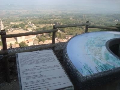
Location. 43° 49.403′ N, 5° 18.511′ E. Marker is in Bonnieux, Provence-Alpes-Côte d'Azur (Provence-Alps-French Riviera), in Vaucluse. Marker is on Rue de la Mairie. This marker is located at the Belvedere, the overlook below the Old Church. Touch for map. Marker is in this post office area: Bonnieux, Provence-Alpes-Côte d'Azur 84480, France. Touch for directions.
Other nearby markers. At least 8 other markers are within walking distance of this marker. Belvedere (a few steps from this marker); La Vieille Eglise (within shouting distance of this marker); Ancien Hotel de Ville ou Hotel de Rouvil (within shouting distance of this marker); Escaliers Emile Gardon (about 90 meters away, measured in a direct line); Rue Voltaire (about 120 meters away); Place du Moulin a Huile (about 120 meters away); Rue Droite (about 150 meters away); a different marker also named Rue Droite (about 150 meters away). Touch for a list and map of all markers in Bonnieux.
Also see . . . Bonnieux. Wikipedia entry (Submitted on November 17, 2023, by Larry Gertner of New York, New York.)
Credits. This page was last revised on November 17, 2023. It was originally submitted on December 19, 2012, by Barry Swackhamer of Brentwood, California. This page has been viewed 448 times since then and 3 times this year. Photos: 1, 2, 3. submitted on December 19, 2012, by Barry Swackhamer of Brentwood, California. • Bill Pfingsten was the editor who published this page.


