San Juan Bautista in San Benito County, California — The American West (Pacific Coastal)
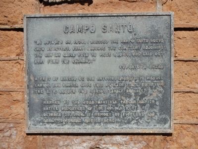
Campo Santo
Fr. Antonio Anzar
A part of Rancho de San Antonio, granted to Manuel Larios. Don Manuel gave this cemetery site, reserving the S.W. corner for Larios family burials.
Marked by the San Juan Bautista Parlor No. 179, Native Daughters of the Golden West, October 28, 1966 in memory of pioneers and early settlers buried here.
Erected 1966 by Native Daughters of the Golden West, San Juan Bautista Parlor No. 179.
Topics and series. This historical marker is listed in this topic list: Cemeteries & Burial Sites. In addition, it is included in the Native Sons/Daughters of the Golden West series list. A significant historical month for this entry is October 1848.
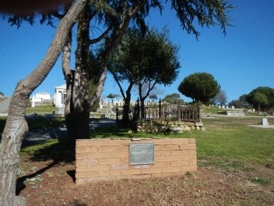
Location. 36° 50.752′ N, 121° 32.687′ W. Marker is in San Juan Bautista, California, in San Benito County. Marker is on Monterey Street west of Church Street, on the right when traveling west. Touch for map. Marker is at or near this postal address: 75 Monterey Street, San Juan Bautista CA 95045, United States of America. Touch for directions.
Other nearby markers. At least 8 other markers are within walking distance of this marker. Patrick and Margaret Breen (a few steps from this marker); San Juan Bautista WW II Veterans (within shouting distance of this marker); Marentis House (about 700 feet away, measured in a direct line); Carl M. Luck Gas Station (approx. ¼ mile away); Jim Jack’s Cabin (approx. ¼ mile away); Fremont Peak (approx. 0.3 miles away); Safety Follows Wisdom (approx. 0.3 miles away); Old School House (approx. 0.4 miles away). Touch for a list and map of all markers in San Juan Bautista.
Credits. This page was last revised on October 25, 2018. It was originally submitted on January 20, 2013, by Barry Swackhamer of Brentwood, California. This page has been viewed 542 times since then and 35 times this year. Last updated on October 24, 2018, by James King of San Miguel, California. Photos: 1, 2. submitted on January 20, 2013, by Barry Swackhamer of Brentwood, California.

