Lima in Allen County, Ohio — The American Midwest (Great Lakes)
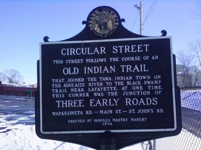
Circular Street
Erected 1954 by Pangles' Master Market.
Topics. This historical marker is listed in these topic lists: Native Americans • Roads & Vehicles • Settlements & Settlers.
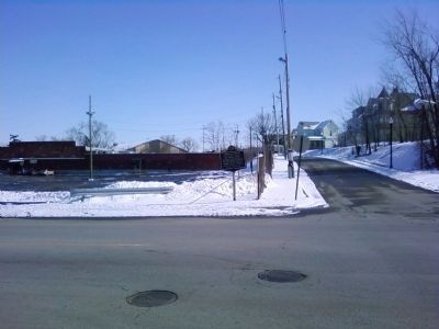
Location. 40° 43.967′ N, 84° 6.297′ W. Marker is in Lima, Ohio, in Allen County. Marker is at the intersection of South Main Street and Circular Street, on the right when traveling north on South Main Street. Marker is on the northeast corner of the intersection. Touch for map. Marker is in this post office area: Lima OH 45804, United States of America. Touch for directions.
Other nearby markers. At least 8 other markers are within walking distance of this marker. Korean War Memorial (approx. half a mile away); The Shawnee Indian Reservation (approx. half a mile away); American Legion Post No. 96 Veterans Memorial Wall (approx. half a mile away); The Inn (approx. half a mile away); Bessie Crayton (approx. half a mile away); The Interurban Era (approx. half a mile away); BP America (approx. half a mile away); Faurot Opera House (approx. 0.6 miles away). Touch for a list and map of all markers in Lima.
More about this marker. The marker was unveiled Nov. 13, 1954, as part of the Ohio Sesquicentennial marker project by the Historic Sites Committee of the Allen County Historical Society, having been funded by Pangles.
Credits. This page was last revised on September 21, 2020. It was originally submitted on February 7, 2013, by Lee Hattabaugh of Capshaw, Alabama. This page has been viewed 1,079 times since then and 37 times this year. Photos: 1, 2. submitted on February 7, 2013, by Lee Hattabaugh of Capshaw, Alabama. • Bill Pfingsten was the editor who published this page.

