Hilton Head Island in Beaufort County, South Carolina — The American South (South Atlantic)
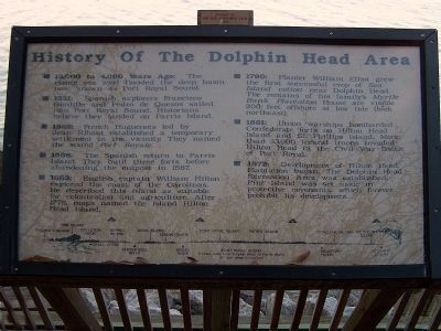
History Of The Dolphin Head Area
(Hilton Head Island)

Photographed By Mike Stroud, March 7, 2009
1. History Of The Dolphin Head Area Marker
1893 - An enormous hurricane hit Beaufort County, killing at least 2,000 people in the county and flooding parts of the island with its 12-foot surge. Many of Hilton Head Island's structures were destroyed in this storm.
(Left column)
¤ 15,000 to 4,000 Years Ago: The
rising sea level flooded the deep basin
now known as Port Royal Sound.
¤ 1531: Spanish explorers Francisco
Gordillo and Pedro de Quexos sailed
into Port Royal Sound. Historians
believe they landed on Parris Island.
¤ 1562: French Huguenots led by
Jean Rebaut established a temporary
settlement in the vicinity. They named
the sound Port Royale.
¤ 1566: The Spanish return to Parris
Island. They build three forts before
abandoning the outpost in 1587.
¤ 1663: English captain William Hilton
explored the coast of the Carolinas.
He described this island as suitable
for colonization and agriculture. After
1776, maps named the island Hilton
Head Island.
(Right column)
¤ 1790: Planter William Elliot grew
the first successful crop Sea
cotton near Dolphin Head.
The remains of his family's Myrtle
Bank Plantation house are visible
200 feet offshore at low tide
(look northeast).
¤ 1861: Union warships bombarded
Confederate forts on Hilton Head
Island and St. Phillips Island. More
than 13,000 federal troops invaded
Hilton Head in the Civil War Battle
of Port Royal.
¤ 1972:Development of Hilton Head
Plantation began. The Dolphin Head
Recreation Area was established.
Pine Island was set aside in
protective covenants, which forever
prohibit its development.
(Bottom)
Panoramic sketch Port Royal Sound Northwest to East
3 miles wide from Dolphin Head to Parris Island
35 feet deep in channel
Erected 2001 by HHP and Gardeners Club.
Topics. This historical marker is listed in this topic list: Notable Places. A significant historical year for this entry is 1531.
Location. 32° 13.196′ N, 80° 40.168′ W. Marker is on Hilton Head Island, South Carolina, in Beaufort County. Marker can be reached from South Port Royal Drive, on the left. Located near the beach house, Port Royal Plantation (a gated Community, restricted access). Touch for map. Marker is in this post office area: Hilton Head Island SC 29928, United States of America. Touch for directions.
Other nearby markers. At least 8 other markers are within 2 miles of this marker, measured as the crow flies. Fort Sherman (approx. 0.6 miles away); "Robbers Row" (approx. one mile away); Fort Walker (approx. one mile away); Hilton Head (approx. 1.2 miles away); Two Gallant Gentlemen from South Carolina (approx. 1.2 miles away); Battle of Port Royal (approx. 1.2 miles away); Steam Gun (approx. 1.2 miles away); The Dawn of Freedom: Mitchelville (approx. 1½ miles away). Touch for a list and map of all markers in Hilton Head Island.
Also see . . . Hilton Head Island History & Heritage. Website homepage (Submitted on June 9, 2023, by Larry Gertner of New York, New York.)
Credits. This page was last revised on June 9, 2023. It was originally submitted on February 20, 2013, by Mike Stroud of Bluffton, South Carolina. This page has been viewed 975 times since then and 74 times this year. Photos: 1, 2, 3. submitted on February 20, 2013, by Mike Stroud of Bluffton, South Carolina.

