Near Welshpool in Charlotte County, New Brunswick — The Atlantic Provinces (North America)
Panoramic View of Cottages
Vue Panoramique des Résidences d'Éte
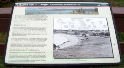
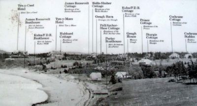
Two of the Campobello Company's founders, Alex S. Porter and Samuel Wells, and several of the luxury hotel visitors, including James Roosevelt and families by the name of Sturgis, Cochrane, Prince, and Pell purchased land and refurbished or built large cottages. Five cottages remain today: the Prince, Roosevelt, Hubbard, Wells-Shober, and Johnston cottages in what is now the Roosevelt Campobello International Park's historic core.
This circa 1914 photo identifies the various structures seen then from the slopes of Friar's Head.
There was no real forest on this end of Campobello at the turn of the last century, for during the early and mid-1800s, island residents cleared most of the land between Welshpool and Friar's Head for planting crops and grazing livestock. Remnants of old fields and apple trees now surrounded by alders or spruce trees help identify historic land use. Hidden by vegetation are old wells and sections of building foundations of former homes, cottages, and barns. The wells have been covered for safety.
—————————
Par la suite, deux des fondateurs de la Campobello Company, Alex S. Porter et Samuel Wells, ainsi que plusieurs autres visiteurs ayant fait des séjours dans les hôtels de l'île - y compris James Roosevelt et les familles Sturgis, Cochrane, Prince et Pell - acquièrent plusieurs terres et entreprirent la restauration et la construction de larges résidences d'été. On y retrouve aujourd'hui cinq résidences d'été, dont celles des Prince, Roosevelt, Hubbard, Wells-Shober et Johnston. Celles-ci forment désormais la majeure partie du patrimoine historique du Parc International Roosevelt de Campobello.
Cette photo prise aux environs de 1914 témoigne des nombreuses structures que l'on pouvait apercevoir alors sur les collines du cap Friar.
Les forêts denses n'existaient plus vraiment à cette extrémité de l'île de Campobello à la fin du dernier siècle. Au début et vers le milieu des années 1880, les habitants de l'île ont défriché la plupart des terres entre Welshpool et la cap Friar pour des fins agricoles et pour y faire la culture et la pâturage. Un nombre d'aulnes et d'épinettes occupent maintenant les champs et les vergers de pommes qui existaient à l'époque. On peut également apercevoir de vieux puits et les sections des fondations d'anciennes résidences et granges. On a condamné les puits pour des raisons de sécurité.
—————————
The photo is from a Real Photo Post Card kindly loaned by Robin H. Wyllie.
Cette photo est une reproduction d'une carte postale d'époque qui nous a généreusement été prêtée par Robin H. Wyllie.
Erected by Roosevelt Campobello International Park.
Topics. This historical marker is listed in these topic lists: Environment • Man-Made Features • Settlements & Settlers. A significant historical year for this entry is 1914.
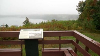
Location. 44° 52.575′ N, 66° 58.315′ W. Marker is near Welshpool, New Brunswick, in Charlotte County. Marker is at the Friar's Head/Cap Friars Observation Deck accessed off Provincial Road 774, about 0.7 miles west of the main entrance to Roosevelt Campobello International Park. Touch for map. Marker is in this post office area: Welshpool NB E5E 1A4, Canada. Touch for directions.
Other nearby markers. At least 8 other markers are within walking distance of this marker. Roosevelt Campobello International Park (here, next to this marker); Mulholland Point / La Pointe Mulholland (here, next to this marker); Passamaquoddy Tidal Power Project (here, next to this marker); Passamaquoddy Tribe / La Tribu Passamaquoddy (here, next to this marker); Friar's Head / Le Cap Friar (here, next to this marker); Campobello Company and Hotels (here, next to this marker); President Franklin Delano Roosevelt (approx. one kilometer away); Roosevelt Campobello Park (approx. one kilometer away). Touch for a list and map of all markers in Welshpool.
Credits. This page was last revised on October 6, 2020. It was originally submitted on March 5, 2013, by William Fischer, Jr. of Scranton, Pennsylvania. This page has been viewed 548 times since then and 8 times this year. Photos: 1, 2, 3. submitted on March 6, 2013, by William Fischer, Jr. of Scranton, Pennsylvania. 4. submitted on March 2, 2013, by William Fischer, Jr. of Scranton, Pennsylvania.


