Pawnee Rock in Barton County, Kansas — The American Midwest (Upper Plains)
"A Rallying Point for the Indians"
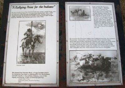
No one actually knows how Pawnee Rock was named. Josiah Gregg, who had been over the Santa Fe Trail eight times beginning in 1831, wrote: the attention of the traveller is directed to the ‘Pawnee Rock' so called, it is said, on account of a battle’s having once been fought hard by, between the Pawnee and some other tribe.
We passed the Pawnee Rock, a huge boulder which for centuries has been a rallying point for the Indians, and still stands, in its solitary majesty, one of the mighty landmarks of this continental journey.
Joseph Allyn Pratt, associate justice, Arizona Territory
1863
Each summer the Pawnees left their villages in Nebraska and northern Kansas and journeyed south to the Arkansas River region to hunt buffalo. The annual migration placed them in the Pawnee Rock vicinity during the peak travel months of the Santa Fe Trail. Because the trail travelers and the Indians usually left each other alone, outright fighting was unusual. Tensions erupted only eighteen times in a twenty-nine-year period between 1822 and 1851. Most of the fights were within twenty-five miles of this site.
On occasion the Pawnees battled their traditional enemies – the Arapahos, Cheyennes, Comanches, and Kiowas. All of these nomadic tribes depended upon buffalo and plants from this area. Heavy use of the Santa Fe Trail, and the results of trail travelers hunting wildlife and grazing thousands of mules and oxen, forced tribes into the territories of their enemies. Plains Indians fought one another and trail travelers to protect their territories and their most important food source – the buffalo.
Erected by Kansas State Historical Society.
Topics and series. This historical marker is listed in these topic lists: Animals • Industry & Commerce • Native Americans • Roads & Vehicles. In addition, it is included in the Santa Fe Trail series list. A significant historical year for this entry is 1831.
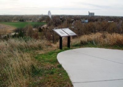
Location. 38° 16.32′ N, 98° 58.917′ W. Marker is in Pawnee Rock, Kansas, in Barton County. Marker is along the walking path atop Pawnee Rock, at Pawnee Rock State Historical Site, off SW 112th Avenue/Center Street. Touch for map. Marker is in this post office area: Pawnee Rock KS 67567, United States of America. Touch for directions.
Other nearby markers. At least 8 other markers are within walking distance of this marker. “One of the Grandest Sights Ever Beheld” (a few steps from this marker); "Along Came the Line of Wagons" (a few steps from this marker); Santa Fe Trail (a few steps from this marker); Marking the Rock (a few steps from this marker); William Becknell (a few steps from this marker);
"A Point of Red Rocks" (a few steps from this marker); a different marker also named “One of the Grandest Sights Ever Beheld” (within shouting distance of this marker); Santa Fe Trail Monument (within shouting distance of this marker). Touch for a list and map of all markers in Pawnee Rock.
Also see . . .
1. Santa Fe National Historic Trail. (Submitted on April 7, 2013, by William Fischer, Jr. of Scranton, Pennsylvania.)
2. Santa Fe Trail Association. (Submitted on April 7, 2013, by William Fischer, Jr. of Scranton, Pennsylvania.)
3. Pawnee Rock State Historic Site, Kansas. (Submitted on April 7, 2013, by William Fischer, Jr. of Scranton, Pennsylvania.)
Credits. This page was last revised on June 16, 2016. It was originally submitted on April 7, 2013, by William Fischer, Jr. of Scranton, Pennsylvania. This page has been viewed 643 times since then and 11 times this year. Photos: 1, 2. submitted on April 7, 2013, by William Fischer, Jr. of Scranton, Pennsylvania.

