Truchas in Rio Arriba County, New Mexico — The American Mountains (Southwest)
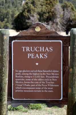
Truchas Peaks
Topics. This historical marker is listed in this topic list: Landmarks.
Location. 36° 3.008′ N, 105° 48.62′ W. Marker is in Truchas, New Mexico, in Rio Arriba County. Marker is on State Road 76 north of Truchas Crossroads, on the right when traveling east. Touch for map. Marker is in this post office area: Truchas NM 87578, United States of America. Touch for directions.
Other nearby markers. At least 8 other markers are within 14 miles of this marker, measured as the crow flies. Truchas (approx. 1.3 miles away); Las Trampas (approx. 6.3 miles away); Chimayo (approx. 7½ miles away); Santuario de Chimayó (approx. 8 miles away); Pueblo of Picuris (approx. 11.2 miles away); Maria Ramita Simbola Martinez "Summer Harvest" (1884-1969) (approx. 11.2 miles away); Velarde (approx. 12.3 miles away); Embudo Stream-Gaging Station (approx. 13.1 miles away).
Also see . . . Wikipedia Entry. “The entire mountain is a small north-south trending massif with four identifiable summits, North Truchas Peak, Middle Truchas Peak, "Medio Truchas Peak" (unofficial name), and South Truchas Peak, the highest. Of the three subsidiary summits, only North Truchas Peak, 13,024 ft (3,970 m) has enough topographic prominence (about 650 ft or 200 m) to be considered an independent peak.” (Submitted on May 1, 2013.)
Credits. This page was last revised on June 16, 2016. It was originally submitted on April 30, 2013, by J. J. Prats of Powell, Ohio. This page has been viewed 592 times since then and 30 times this year. Photos: 1, 2. submitted on April 30, 2013, by J. J. Prats of Powell, Ohio.

