Near Platte City in Platte County, Missouri — The American Midwest (Upper Plains)
Platte County
[Front]
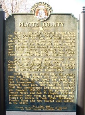
Platte is one of 6 counties formed from the U.S. Government's 1836 Platte Purchase in which Iowa, Sac, Fox, and small bands of other Indian tribes gave up over 2 million acres of land for $7,500 and other benefits. The Purchase was annexed to Missouri, 1837, and Platte County, comprising 414 square miles, was organized, 1838. The name comes from the nearby Platte (Fr. shallow) River.
In a fertile, glacial plains region, Platte County, early leading hemp grower, is now noted for its tobacco, grain, livestock farms. Missouri's oldest continuing county fair is Platte County's begun, 1858.
First settler near Platte City, the county seat, was Zadoc Martin who came, 1828, and ran a Platte River ferry for traffic to Fort Leavenworth. Weston, early thriving Missouri River port, now noted for its pre-Civil War architecture and tobacco market, was founded, 1837-38, to the northwest by Joseph Moore and Bela M. Hughes. Parkville, prominent early town to the southeast was settled by George S. Park, 1838. Northward Camden Point and New Market were settled in the 1840's.
(See other side)
[Back]
(Continued from other side)
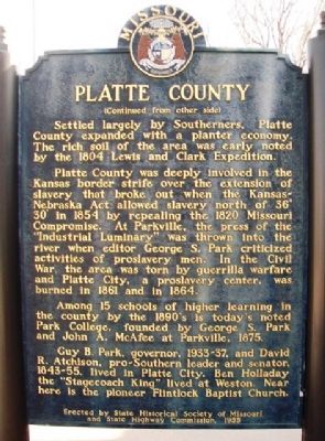
Settled largely by Southerners, Platte County expanded with a planter economy. The rich soil of the area was early noted by the 1804 Lewis and Clark Expedition.
Platte County was deeply involved in the Kansas border strife over the extension of slavery that broke out when the Kansas-Nebraska Act allowed slavery north of 36° 30' in 1854 by repealing the 1820 Missouri Compromise. At Parkville, the press of the "Industrial Luminary" was thrown into the river when editor George S. Park criticized activities of proslavery men. In the Civil War, the area was torn by guerrilla warfare and Platte City, a proslavery center, was burned in 1861 and in 1864.
Among 15 schools of higher learning in the county by the 1890's is today's noted Park College, founded by George S. Park and John A. McAfee at Parkville, 1875.
Guy B. Park, governor, 1933-37, and David R. Atchison, pro-Southern leader and senator, 1843-55, lived in Platte City. Ben Holladay the "Stagecoach King" lived at Weston. Near here is the pioneer Flintlock Baptist Church.
Erected 1955 by State Historical Society of Missouri and State Highway Commission.
Topics and series. This historical marker is listed in these topic lists: Education • Native Americans • Settlements & Settlers • War, US Civil. In addition, it is included in the Missouri, The State Historical Society of series list. A significant historical year for this entry is 1836.
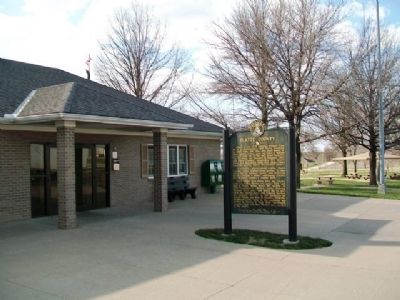
Location. 39° 28.572′ N, 94° 47.282′ W. Marker is near Platte City, Missouri, in Platte County. Marker is on Interstate 29, on the right when traveling south. Marker is next to the convenience station at the southbound Dearborn Rest Area, about seven miles north of Platte City. Touch for map. Marker is in this post office area: Platte City MO 64079, United States of America. Touch for directions.
Other nearby markers. At least 8 other markers are within 8 miles of this marker, measured as the crow flies. Camden Point Veterans' Marker (approx. 2.3 miles away); Weston Veterans Memorial (approx. 6.9 miles away); Laurel Hill Cemetery (approx. 7.2 miles away); a different marker also named Laurel Hill Cemetery (approx. 7.2 miles away); a different marker also named Laurel Hill Cemetery (approx. 7.2 miles away); a different marker also named Laurel Hill Cemetery (approx. 7.2 miles away); a different marker also named Laurel Hill Cemetery (approx. 7.3 miles away); Guy B. Park (approx. 7.3 miles away).
Also see . . .
1. Platte County Historical & Genealogical Society. Society website homepage (Submitted on July 4, 2013, by William Fischer, Jr. of Scranton, Pennsylvania.)
2. Platte County, Missouri. Official website homepage (Submitted on July 4, 2013, by William Fischer, Jr. of Scranton, Pennsylvania.)
Credits. This page was last revised on June 6, 2022. It was originally submitted on July 4, 2013, by William Fischer, Jr. of Scranton, Pennsylvania. This page has been viewed 921 times since then and 37 times this year. Photos: 1, 2, 3. submitted on July 4, 2013, by William Fischer, Jr. of Scranton, Pennsylvania.


