Wabasha in Wabasha County, Minnesota — The American Midwest (Upper Plains)
Wapahasha I / Wapahasha II / Wapahasha III
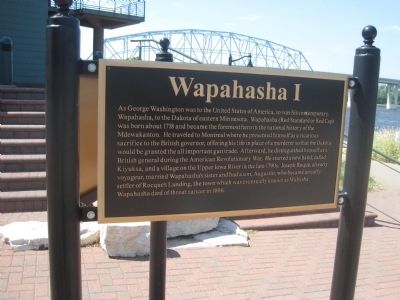
As George Washington was to the United States of America, so was his contemporary, Wapahasha, to the Dakota of eastern Minnesota. Wapahasha (Red Standard or Red Cap) was born about 1718 and became the foremost hero in the national history of the Mdewakanton. He traveled to Montreal where he presented himself as a vicarious sacrifice to the British governor, offering his life in place of a murderer so that the Dakota would be granted the all important gun trade. Afterward, he distinguished himself as a British general during the American Revolutionary War. He started a new band, called Kiyuksa, and a village on the Upper Iowa River in the late 1790s. Joseph Roque, an early voyageur, married Wapahasha's sister and had a son, Augustin, who became an early settler of Rocque's Landing, the town which was eventually known as Wabasha. Wapahasha died of throat cancer in 1806.
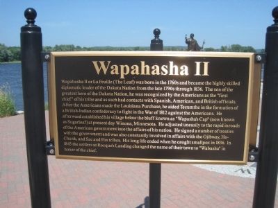
Wapahasha II or La Feuille (The Leaf) was born in the 1760s and became the highly skilled diplomatic leader of the Dakota Nation from the late 1790s through 1836. The son of the greatest hero of the Dakota Nation, he was recognized by the Americans as the "first chief" of his tribe and as such had contacts with Spanish, American, and British officials. After the Americans made the Louisiana Purchase, he aided Tecumthe in the formation of a British-Indian confederacy to fight in the war of 1812 against the Americans. He afterward establish his village below the bluff known as "Wapasha's Cap" (now known as Sugarloaf) at present day Winona, Minnesota. He adjusted uneasily to the rapid inroad with the government into the affairs of his nation. He signed a number of treaties with the government and was also constantly involved in affairs with the Ojibway, Ho-Chunk, and Sac and Fox tribes. His long life ended when he caught smallpox in 1836. In 1843 the settlers at Rocque's Landing changed the name of their town to "Wabasha" in honor of the chief.
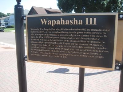
Wapahasha III or Tatepsin (Bounding Wind) was born about 1812 and emerged as a tribal leader in the 1840s. At first strongly defiant against the government's control over his tribe, he was gradually persuaded to accept the religion and custom of the whites. He signed the 1851 and 1858 land cession treaties which created the southern half of Minnesota. While at the Dakota Reserve on the Minnesota River, he came under the influence of Episcopal Bishop Henry B. Whipple and was converted to Christianity. He opposed the Dakota War of 1862 and afterward suffered the humiliating removal to Crow Creek, Dakota Territory, where 300 people died from lack of food and medical care. He then helped his people rebuild their lives at the Niobrara, or Santee, Reserve in Nebraska, though for a decade they were plagued by uncertain land tenure, drought, grasshoppers, and smallpox. He died in 1876.
Topics. This historical marker is listed in these topic lists: Native Americans • Settlements & Settlers. A significant historical year for this entry is 1718.
Location. 44° 23.048′ N, 92° 1.861′ W. Marker is in Wabasha, Minnesota, in Wabasha County. Marker is at the intersection of Lawrence Boulevard East and Pembroke Avenue, on the right when traveling west on Lawrence Boulevard East. Touch for map. Marker is at or near this postal address: 50 Pembroke Ave, Wabasha MN 55981, United States of America. Touch for directions.
Other nearby markers. At least 8 other markers are within 5 miles of this marker, measured as the crow flies. The Bridge (approx. 0.2 miles away); Grace Memorial Episcopal Church (approx. 0.2 miles away); Minnesota Territory 1849-1858 / Wabasha County Takes Shape (approx. 0.3 miles away); Veterans Memorial (approx. 0.4 miles away); a different marker also named Veterans Memorial (approx. 2.7 miles away in Wisconsin); Lake Pepin (approx. 4.2 miles away); a different marker also named Lake Pepin (approx. 4.2 miles away); The River of Rafts (approx. 4.2 miles away). Touch for a list and map of all markers in Wabasha.
Credits. This page was last revised on June 16, 2016. It was originally submitted on July 22, 2013. This page has been viewed 1,438 times since then and 141 times this year. Photos: 1, 2, 3, 4. submitted on July 22, 2013. • Bernard Fisher was the editor who published this page.


