Near Elko in Elko County, Nevada — The American Mountains (Southwest)
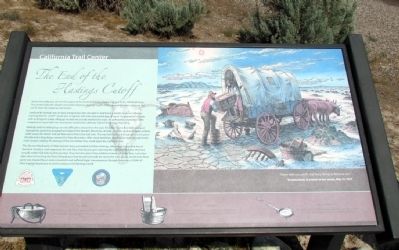
The End of the Hastings Cutoff
Lansford W. Hastings was an early entrepreneur who thought he had found a shorter route to California, claiming that his "cutoff" would save emigrants 400 miles and several days of travel. He promoted this route with an Emigrant Guide. Although he had not actually traveled the route, he persuaded a number of 1846 emigrants to travel with him, leaving the established California Trail at Fort Bridger, Wyoming.
Hastings and his initial group ran into difficulties almost from the start. First, they had to find their way west through the punishing geographical maze of the Wasatch Mountains of Utah, and then endure 80 miles without water across the desert and salt flats west of the Great Salt Lake. This was followed by the high desert of eastern Nevada and a long detour around the Ruby Mountains. After these hardships, they had to travel through South Fork Canyon, making 14 crossings of the river before they could rejoin the California Trail.
The Donner-Reed party of 1846 had also been persuaded to follow Hastings. After much travel and loss of livestock, furniture, and wagons on the Salt Flats, they found upon rejoining the California Trail that they had actually added 125 miles to their journey. They also spent three additional weeks of travel time. Just a few days short of reaching the Sierra Nevada pass that would eventually be named for their group, the Donner-Reed party was trapped by an early snowstorm and suffered tragic consequences through the winter of 1846-47. Their tragedy put an end to travel on the Hastings Cutoff.
(Drawing Caption)
"Never take no cutoffs and hury along as fast you can."
Virginia Reed, in a letter to her cousin, May 16, 1847
Erected by Bureau of Land Management.
Topics and series. This historical marker is listed in these topic lists: Roads & Vehicles • Settlements & Settlers. In addition, it is included in the California Trail series list. A significant historical date for this entry is May 16, 1847.
Location. 40° 46.026′ N, 115° 55.354′ W. Marker is near Elko, Nevada, in Elko County. Marker can be reached from Interstate 80 at milepost 292, on the right when traveling west. To visit the marker, exit I-80 at Exit 292 (Hunter) and follow the directional signs to the California Emigrant Trail Interpretive Center; the marker is at the gated entrance to the Center. Touch for map. Marker is in this post office area: Elko NV 89801, United States of America. Touch for directions.
Other nearby markers.
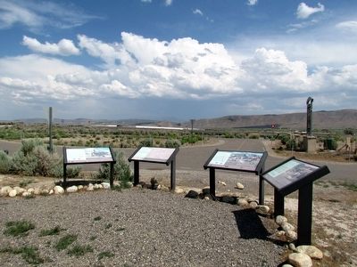
At least 8 other markers are within 6 miles of this marker, measured as the crow flies. About Your Journey ... (here, next to this marker); The Humboldt River Highway (here, next to this marker); The California Emigrant Trail Interpretive Center (here, next to this marker); Marking Time (a few steps from this marker); California Trail - Greenhorn Cutoff (a few steps from this marker); West End of Hastings Cutoff (approx. 0.2 miles away); Hoppe-Lienhard Wagon Group (approx. 0.2 miles away); California Trail - Carlin Canyon (approx. 5.3 miles away). Touch for a list and map of all markers in Elko.
Also see . . .
1. California Trail Interpretive Center Website. (Submitted on August 10, 2013, by Duane Hall of Abilene, Texas.)
2. Wikipedia Entry for Hastings Cutoff. “The cutoff left the Oregon Trail at Fort Bridger in Wyoming, passed through the Wasatch Range, across the Great Salt Lake Desert, an 80-mile waterless drive, looped around the Ruby Mountains, and rejoined the California Trail about seven miles west of modern Elko (also Emigrant Pass).” (Submitted on May 16, 2020.)
3. Wikipedia Entry for the Donner Party. Excerpt:
By early November, the migrants had reached the Sierra Nevada but became trapped by an early, heavy snowfall near Truckee Lake (now Donner Lake) high in the mountains. Their food supplies ran dangerously low, and in mid-December some of the group set out on foot to obtain help. Rescuers from California attempted to reach the migrants, but the first relief party did not arrive until the middle of February 1847, almost four months after the wagon train became trapped. Of the 87 members of the party, 48 survived the ordeal. Historians have described the episode as one of the most spectacular tragedies in California history, and in the entire record of American westward migration.(Submitted on May 16, 2020.)
Credits. This page was last revised on May 16, 2020. It was originally submitted on August 10, 2013, by Duane Hall of Abilene, Texas. This page has been viewed 1,095 times since then and 57 times this year. It was the Marker of the Week May 17, 2020. Photos: 1, 2. submitted on August 10, 2013, by Duane Hall of Abilene, Texas. 3. submitted on August 9, 2013, by Duane Hall of Abilene, Texas. 4. submitted on May 16, 2020, by J. J. Prats of Powell, Ohio.


