Liberty in Clay County, Missouri — The American Midwest (Upper Plains)
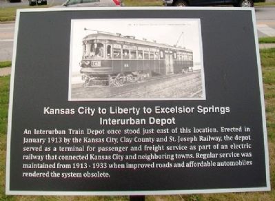
Kansas City to Liberty to Excelsior Springs Interurban Depot
Inscription.
An Interurban Train Depot once stood just east of this location. Erected in January 1913 by the Kansas City, Clay County and St. Joseph Railway, the depot served as a terminal for passenger and freight service as part of an electric railway that connected Kansas City and neighboring towns. Regular service was maintained from 1913-1933 when improved roads and affordable automobiles rendered the system obsolete.
Topics. This historical marker is listed in this topic list: Railroads & Streetcars. A significant historical month for this entry is January 1913.
Location. 39° 14.675′ N, 94° 25.024′ W. Marker is in Liberty, Missouri, in Clay County. Marker is at the intersection of Mill Street (Missouri Route H) and Leonard Street (Missouri Route 33), on the right when traveling east on Mill Street. Touch for map. Marker is in this post office area: Liberty MO 64068, United States of America. Touch for directions.
Other nearby markers. At least 8 other markers are within walking distance of this marker. Methodist Episcopal Church Founded 1822 (about 400 feet away, measured in a direct line); The Liberty Spring (about 500 feet away); Founding Fathers (about 600 feet away); John Dougherty (about 600 feet away); Clay County American Revolution Veterans (about 700 feet away); Jurisprudence (about 700 feet away); Lewis and Clark Mural (about 700 feet away); First Court House Site (about 700 feet away). Touch for a list and map of all markers in Liberty.
Also see . . .
1. The Story of Light Rail Transportation in Ole St. Joe. Kansas City, Clay County & St. Joseph Interurban Railway website entry (Submitted on August 30, 2013, by William Fischer, Jr. of Scranton, Pennsylvania.)
2. "Early commuters rode interurban" Harry Soltysiak article (1989). The Idle Hour website entry (Submitted on August 30, 2013, by William Fischer, Jr. of Scranton, Pennsylvania.)
Credits. This page was last revised on April 28, 2022. It was originally submitted on August 30, 2013, by William Fischer, Jr. of Scranton, Pennsylvania. This page has been viewed 857 times since then and 75 times this year. Photos: 1, 2. submitted on August 30, 2013, by William Fischer, Jr. of Scranton, Pennsylvania.

