Guatemala City in Guatemala Department, — Central America
The Central American Act of Independence
Acta de Independencia de Centroamerica
— Independencia de Guatemala —
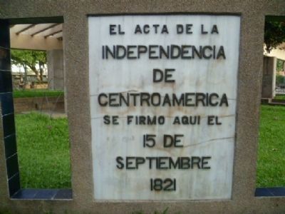
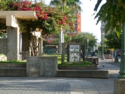
Inscription.
Independencia
de
Centroamerica
se firmo aqui el
15 de
Septiembre
1821
was signed here the 15th of September 1821.
Topics. This historical marker is listed in these topic lists: Colonial Era • Government & Politics. A significant historical date for this entry is September 15, 1821.
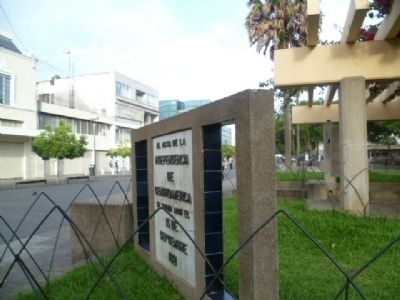
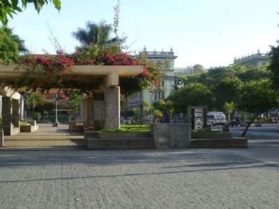
Location. 14° 38.484′ N, 90° 30.845′ W. Marker is in Guatemala City, Guatemala (Guatemala Department). Marker is at the intersection of 6 Avenida, on the left when traveling north on 6 Avenida. It is in Parque Centenario on the northwest corner of the intersection of 6th Avenue and 8th Street, Zona 1 Guatemala City, Guatemala, Central America. Touch for map. Marker is at or near this postal address: 6 Avenida y 8 Calle, Zona 1, Ciudad de Guatemala, Guatemala City, Guatemala 01001, Guatemala. Touch for directions.
Other nearby markers. At least 8 other markers are within walking distance of this marker. Paseo de la Sexta (here, next to this marker); Shopping Arcade (a few steps from this marker); Assassination of Oliverio Castañeda de Leon (within shouting distance of this marker); Tragedy of the “Virgen de la Asunción” Safe Home (about 120 meters away, measured in a direct line); National Day of Dignity for the Victims of Guatemala's Armed Conflict (about 120 meters away); The Aycinena Arcade (about 120 meters away); Guatemalan Revolution of 1944 (about 150 meters away); Memorial to the Victims of Guatemala's Armed Conflict (about 150 meters away). Touch for a list and map of all markers in Guatemala City.
Regarding The Central American Act of Independence.
The Act of Independence of Central America (September 15, 1821)
The conquest of the Americas marks both an historical and economic era of significant global transcendence. The Spanish monarchy exploited several important economic aspects of this colonial territory expansion. Carrying out details of this massive endeavor was granted by the Spanish crown to royal designates and private individuals. Their political-administrative system, of the Americas, was divided into provinces that covered vast amounts of the western hemisphere. The unequal development of these provinces
and the power shifts in the province capitals had significant consequences for both political and economic colonial systems. Part of that territory included the General Captaincy of the Kingdom of Guatemala. This region was comprised in part by what today is known as Chiapas, Mexico, Guatemala, Honduras, El Salvador, Nicaragua and Costa Rica. (1) H. Cabezas Carcache
The causes of the Central American region’s political independence are diverse and controversial. However, these events were essential to the development of the region’s present nations. In the General Archive of Central America, there are many historical documents that describe the political, social, economic, religious differences that existed in the region between the 16th and 18th centuries. The French occupation of Spain and the developing “New World” economic challenges of the General Captaincy created major shifts in control at the heart of the colonial monarchy. The situation was aggravated by similar movements in several parts of the Americas; along with the pressure to adhere to Mexico’s “Plan de Iguala”. These socio-political and economic problems had direct influences on the events that led to the region’s independence on September 15, 1821. (2) General Archive of Central America
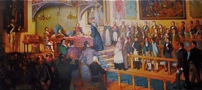
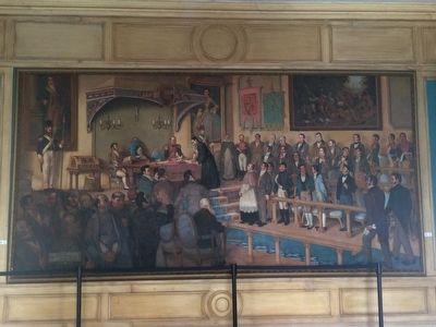
On September 14, 1821; the Spanish Captain General of the Royal Audience, President Gabino Gainza, convoked a General Assembly at the Royal Palace. At the meeting the following institutions were present: Archbishop, Royal Audience, City Council, University of San Carlos faculty, College of Attorneys, War Council, General Chiefs, Provincial Council, Board of Physicians. During the meeting, noble elite individuals and families were also in the surrounding areas. The events culminated in the Declaration of Independence from the Spanish Crown. (3) University of San Carlos Center for Urban Studies USAC CEUR
The Act of Independence was signed, on September 15th, 1821, at the Palace of the General Captaincy (Palacio de Capitanes Generales). Built in the mid 1770s, this palace was located where the Parque Centenario (Centenary Park) is now located on 6th Avenue and 8th Streets in Zone 1 of Guatemala City. The building was destroyed during the earthquakes of 1917-1918. A historical marker now sits commemorating the Declaration of Independence of the Provinces of Central America. Today, Guatemaltecos visit the park and Guatemala urban life continues to make its own stories in this area of historical significance.
Bibliography and Resources:
1. Independencia Centroamericana: Gestion y Ocaso del Plan Pacifo. 2010. Editorial Universitaria, Universidad de San Carlos de Guatemala. Cabezas Carcache, H.
2. General Archive of Central America, Guatemala City, Guatemala
3. University of San Carlos of Guatemala, Center for Urban Studies, http://www.ceur.usac.edu.gt/
4. Hemeroteca Nacional de Guatemala, National Newspaper Library of Guatemala, http://www.culturacentroamericana.info/guatemala/patrimonio-tangible/archivos-bibliotecas-y-hemerotecas/81-hemeroteca-nacional-guatemala
Also see . . . Federal Republic of Central America. Wikipedia article (retrieved 09/12/2013) on the Federal Republic of Central America. On the declaration of independence, ...Finally on September 14, in Guatemala City, the Captain General and his councilors convoked a General Assembly of dignitaries (including the Archbishop, the heads of the Military branches, the Mayor of Guatemala and his Council and others) to review the question. Before this assembly could be installed, a Popular Assembly called by the City Council which included deputies from the provinces and the citizenry of Guatemala declared independence and the Deed of Declaration of Independence ("Acta de Independencia") was signed and proclaimed on September 15, 1821, which is now recognized as Independence Day by five Central American republics. The five republics are El Salvador, Guatemala, Nicaragua, Honduras, and Costa Rica. (Submitted on September 13, 2013.)
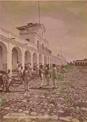
Photographed By Eadweard Muybridge, circa 1875
6. Palacio de Capitanes Generales (Palace of the Captaincy General)
This image, by noted photographer Eadweard Muybridge, is the right half of a stereograph, showing the Palacio de Capitanes Generales, the site of the signing of the Central American Declaration of Independence, as it appeared in 1875.
Credits. This page was last revised on January 29, 2018. It was originally submitted on September 10, 2013, by Jo Solorzano of San Francisco, California. This page has been viewed 1,906 times since then and 81 times this year. It was the Marker of the Week September 15, 2013. Photos: 1, 2, 3, 4, 5, 6. submitted on September 10, 2013, by Jo Solorzano of San Francisco, California. 7. submitted on March 21, 2015, by J. Makali Bruton of Accra, Ghana. • Andrew Ruppenstein was the editor who published this page.
