Waverly in Humphreys County, Tennessee — The American South (East South Central)
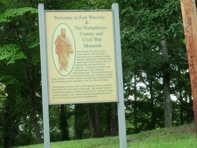
Welcome to Fort Waverly & The Humphreys County and Civil War Museum
Inscription.
Fort Waverly was built by Union troops between 1863 and 1864. It protected a newly completed railroad line that connected the important Union supply depot on the Tennessee River in Johnsonville with Federally held Nashville. Confederate guerillas posted constant threats to these important transportation links. The Federal fortification lies on the rise before you. Interpretive signage at the entrance to the fort explains in greater detail information about the fortification and its importance to the Civil War in this area.
The Humpreys County and Civil War Museum houses a collection that reflects the rich heritage of the county. The museum stands as an important repository of items of local interest, prehistoric Native American artifacts and a special collection interpreting the role of the Civil War in the county and surrounding area.
Topics. This historical marker is listed in these topic lists: Forts and Castles • War, US Civil. A significant historical year for this entry is 1863.
Location. 36° 4.883′ N, 87° 47.533′ W. Marker is in Waverly, Tennessee, in Humphreys County. Marker can be reached from Fort Hill Road, 0.2 miles east of South Church Street (Tennessee Route 13), on the right when traveling east. Touch for map. Marker is at or near this postal address: 201 Fort Hill Rd, Waverly TN 37185, United States of America. Touch for directions.
Other nearby markers. At least 8 other markers are within walking distance of this marker. The Butterfield House (a few steps from this marker); Fort Waverly (within shouting distance of this marker); Fort Hill at Waverly (within shouting distance of this marker); Fort Hill (about 700 feet away, measured in a direct line); Reynoldsburg (approx. 0.2 miles away); Humphreys County War Memorial (approx. 0.2 miles away); Battle of Johnsonville (approx. 0.2 miles away); Humphreys County (approx. 0.2 miles away). Touch for a list and map of all markers in Waverly.
Credits. This page was last revised on June 16, 2016. It was originally submitted on September 30, 2013, by Don Morfe of Baltimore, Maryland. This page has been viewed 1,115 times since then and 62 times this year. Photos: 1, 2. submitted on September 30, 2013, by Don Morfe of Baltimore, Maryland. • Bernard Fisher was the editor who published this page.

