Sweetwater in Monroe County, Tennessee — The American South (East South Central)
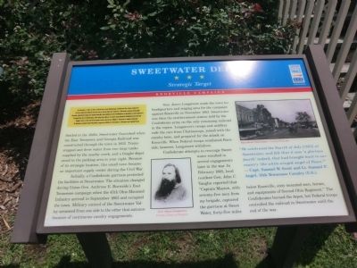
Sweetwater Depot
Strategic Target
— Knoxville Campaign —
On November 4, 1863, to divert Federal forces from Chattanooga, Confederate Gen. James Longstreet led two reinforced divisions from the city to attack Union Gen. Ambrose E. Burnside’s garrison in Knoxville. Burnside confronted Longstreet outside Knoxville, then withdrew to his fortification on November 12, and Longstreet besieged the city. In Chattanooga, after Union Gen. Ulysses S. Grant’s army defeated Confederate Gen. Braxton Bragg’s forces at the end of the month, Grant ordered Gen. William T. Sherman to reinforce Burnside. As Sherman marched toward Knoxville, Longstreet withdrew on December 4. Sherman soon rejoined Grant.
(main text)
Settled in the 1820s, Sweetwater flourished when the East Tennessee and Georgia Railroad was constructed through the town in 1852. Trains stopped and drew water from two large tanks supplied by the nearby creek, and a freight depot stood in the parking area to your right. Because of its strategic location, this small town became an important supply center during the Civil War. Initially, a Confederate garrison protected the facilities at Sweetwater. The situation changed during Union Gen. Ambrose E. Burnside’s East Tennessee campaign when the 45th Ohio Mounted Infantry arrived in September 1863 and occupied the town. Military control of the Sweetwater Valley seesawed from one side to the other that autumn because of continuous cavalry engagements.
Gen. James Longstreet made the town his headquarters and staging area for the campaign against Knoxville in November 1863. Sweetwater was then the northernmost station held by the Confederate army on the only remaining railroad in the region. Longstreet’s troops and artillery rode the cars from Chattanooga, joined with the cavalry here, and prepared for the attack on Knoxville. When Federal troops reinforced Burnside, however, Longstreet withdrew.
Confederate attempts to reoccupy Sweetwater resulted in several engagements later in the war. In February 1865, local resident Gen. John C. Vaughn reported that “Captain Maston, with seventy-five men from my brigade, captured the garrison at Sweet Water, forty-five miles below Knoxville, sixty mounted men, horses, and equipments of Second Ohio Regiment.” The Confederates burned the depot, but Federal troops controlled the railroad in Sweetwater until the end of the war.
“We celebrated the Fourth of July (1865) at Sweetwater, and felt that it was ‘a glorious fourth’ indeed, that had brought back to our country ‘the white-winged angel of Peace.’” — Capt. Samuel W. Scott and Lt. Samuel P. Angel, 13 Tennessee Cavalry (U.S.)
(captions)
Gen. James Longstreet Courtesy Library of Congress
Main Street, Sweetwater - Courtesy Philip Roy
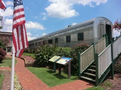
Erected by Tennessee Civil War Trails.
Topics and series. This historical marker is listed in these topic lists: Railroads & Streetcars • War, US Civil. In addition, it is included in the Tennessee Civil War Trails series list. A significant historical month for this entry is February 1865.
Location. 35° 35.978′ N, 84° 27.728′ W. Marker is in Sweetwater, Tennessee, in Monroe County. Marker is at the intersection of North Main Street (U.S. 11) and East Walnut Street, on the right when traveling north on North Main Street. Touch for map. Marker is in this post office area: Sweetwater TN 37874, United States of America. Touch for directions.
Other nearby markers. At least 8 other markers are within 7 miles of this marker, measured as the crow flies. The Tennessee Overhill Experience (here, next to this marker); Captain John M. Jones, CSA (approx. 0.2 miles away); Longstreet Encampment (approx. 0.3 miles away); T M I Academy (approx. 0.9 miles away); Tennessee Meiji Gakuin High School 1989-2007 (approx. one mile away); The Great Craighead Cave (approx. 4.8 miles away); Lost Sea (approx. 4.8 miles away); Affair at Philadelphia (approx. 6.3 miles away). Touch for a list and map of all markers in Sweetwater.
Credits. This page was last revised on June 16, 2016. It was originally submitted on October 15, 2013, by Don Morfe of Baltimore, Maryland. This page has been viewed 1,121 times since then and 67 times this year. Photos: 1, 2, 3. submitted on October 15, 2013, by Don Morfe of Baltimore, Maryland. • Bernard Fisher was the editor who published this page.


