Morganton in Loudon County, Tennessee — The American South (East South Central)
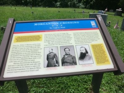
Morganton Crossing
Too Cold to Wade
— Knoxville Campaign —
On November 4, 1863, to divert Federal forces from Chattanooga, Confederate Gen. James Longstreet led two reinforced divisions from the city to attack Union Gen. Ambrose E. Burnside’s garrison in Knoxville. Burnside confronted Longstreet outside Knoxville, then withdrew to his fortification on November 12, and Longstreet besieged the city. In Chattanooga, after Union Gen. Ulysses S. Grant’s army defeated Confederate Gen. Braxton Bragg’s forces at the end of the month, Grant ordered Gen. William T. Sherman to reinforce Burnside. As Sherman marched toward Knoxville, Longstreet withdrew on December 4. Sherman soon rejoined Grant.
(main text)
Union Gen. William T. Sherman and his troops marched north from Chattanooga on November 28, 1863, to relieve the siege of Knoxville. Sherman led the XV Corps up the East Tennessee and Georgia Railroad Line through Philadelphia toward Morganton on the Little Tennessee River. He planned to ford the shallows here at Morganton then continue to Knoxville. The corps arrived from your left on Morganton Rd, which is now under water and near where you stand.
Sherman discovered that the Morganton ford was 3½ feet deep and 240 yards wide, making it impossible for the infantry to wade in the near freezing temperature. Col. James H. Wilson, assistant inspector general from Grant's staff, supervised the construction of a bridge. The troops found two large flatboats and carried forty to fifty men across the river to serve as guards and a working party. Unoccupied houses and barns in Morganton were torn down to obtain wood for the bridge, which was finished on December 4.
Wet, cold, and poorly provisioned, the troops crossed the river. Sherman soon received word that Longstreet appeared to be retreating rather than risk being trapped by the advancing Union forces. Longstreet withdrew to northeastern Tennessee for the winter and later returned to Virginia. His retreat marked the end of the last serious attempt by the Confederacy to hold East Tennessee and the vital supply route between Atlanta and Virginia.
(sidebar)
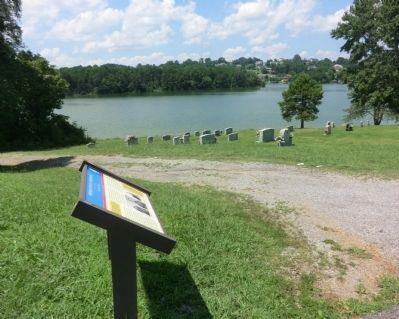
Morganton was a main antebellum shipping hub and business center on the Little Tennessee River. After the Civil War, railroads slowly replaced riverboats in local transportation and Morganton began to decline. In 1968, the Tennessee Valley Authority tore down 18 remaining houses, a store, an a church in preparation for the construction of Tellico Dam. The Morganton Cemetery where you stand now is all that remains. The rest of the town was flooded as a result of the Tellico Dam Project.
(captions)
Col. James H. Wilson Courtesy Library of Congress
Gen William T. Sherman Courtesy Library of Congress
Gen. James Longstreet Courtesy Library of Congress
Erected by Tennessee Civil War Trails.
Topics and series. This historical marker is listed in this topic list: War, US Civil. In addition, it is included in the Tennessee Civil War Trails series list. A significant historical date for this entry is November 4, 1863.
Location. 35° 38.57′ N, 84° 13.398′ W. Marker is in Morganton, Tennessee, in Loudon County. Marker is on Morganton Cemetery Road, 0.6 miles west of East Coast Tellico Parkway, on the right when traveling west. Touch for map. Marker is in this post office area: Greenback TN 37742, United States of America. Touch for directions.
Other nearby markers. At least 8 other markers are within 4 miles of this marker, measured as the crow flies. Militia Springs (approx. 2.3 miles away); Tellico Blockhouse (approx. 3.1 miles away); National Campground (approx. 3.1 miles away); Norwood Inn (approx. 3.1 miles away); Fort Loudon (approx. 3.4 miles away); Unicoi Turnpike Trail (approx. 3.4 miles away); Welcome to Fort Loudoun State Historic Area (approx. 3.4 miles away); Fort Loudoun (approx. 3.4 miles away).
Credits. This page was last revised on June 16, 2016. It was originally submitted on October 15, 2013, by Don Morfe of Baltimore, Maryland. This page has been viewed 906 times since then and 32 times this year. Photos: 1, 2, 3. submitted on October 15, 2013, by Don Morfe of Baltimore, Maryland. • Bernard Fisher was the editor who published this page.


