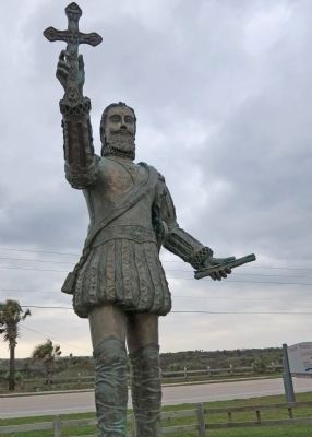
Melbourne Beach in Brevard County, Florida — The American South (South Atlantic)
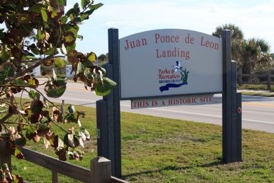
Possible Vicinity of Juan Ponce de Leon’s Landing
Inscription.
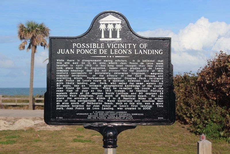
While there is disagreement among scholars, it is believed that this site may be in an area where Juan Ponce de Leon made landfall in April 1513. It has long been thought that this event took place near St. Augustine, based upon studies of de Leon's compass headings that did not account for the inability of 16th century navigators to accurately determine longitude, magnetic compass deviations, or the effects of the Gulf Stream and prevailing winds. Professional navigator Douglas Peck re-traced Juan Ponce de Leon's route in a sailboat, however, and found a more likely landing site. Peck, who sailed the same waters for 30 years, has an "intimate geographical knowledge of the route" Juan Ponce de Leon took. When he re-sailed the route at the same time of year as the 1513 voyage, he reached Florida's eastern shore at 28 degrees North Latitude and 80 degrees 29 minutes West Longitude, just south of Melbourne Beach. He can place the accuracy to within 5 to 8 Nautical Miles on either side of this navigational fix. Many historian now conclude that an area south of Melbourne Beach, such as this site, was a more probable location for Juan Ponce de Leon's first landing. This park, Juan Ponce de Leon Landing, was created in 2005. A Florida Historic Landmark.
Erected 2005 by The Brevard County Historical Commission Brevard Country Parks & Recreation and the Florida Department of State. (Marker Number F-565.)
Topics. This historical marker is listed in this topic list: Exploration. A significant historical month for this entry is April 1513.
Location. 28° 0.617′ N, 80° 31.811′ W. Marker is in Melbourne Beach, Florida, in Brevard County. Marker is on State Road A1A when traveling south. Touch for map. Marker is in this post office area: Melbourne Beach FL 32951, United States of America. Touch for directions.
Other nearby markers. At least 8 other markers are within 5 miles of this marker, measured as the crow flies. Old Melbourne Beach Town Hall (approx. 3.1 miles away); First Roman Catholic Church in Brevard County (approx. 3.8 miles away); Myrtle Cottage (approx. 4½ miles away); Community Chapel of Melbourne Beach Florida (approx. 4½ miles away); The Ryckman House (approx. 4½ miles away); The Villa Marine (approx. 4.6 miles away); Melbourne Beach Pier (approx. 4.6 miles away); Melbourne & Atlantic Railroad (approx. 4.6 miles away). Touch for a list and map of all markers in Melbourne Beach.
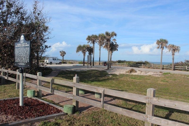
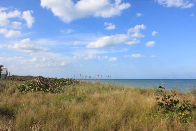
More about this marker. The marker is located in Juan Ponce de Leon Landing park. This park has a beach entrance, parking and restrooms. The marker is only a few feet from Highway A1A at the extreme south end of the park.
Also see . . . Juan Ponce de León. Wikipedia
entry. “For the next several days the fleet crossed open water until April 2, 1513,when they sighted land which Ponce de León believed was another island. He named it La Florida in recognition of the verdant landscape and because it was the Easter season, which the Spaniards called Pascua Florida (Festival of Flowers). The following day they came ashore to seek information and take possession of this new land. The precise location of their landing on the Florida coast has been disputed for many years. Some historians believe it occurred at St. Augustine; others prefer a more southern landing at a small harbor now called Ponce de León Inlet; and some argue that Ponce came ashore even farther south near the present location of Melbourne Beach.” (Submitted on March 31, 2013.)
Additional commentary.
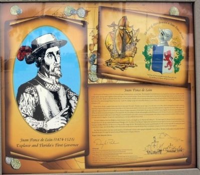
1. Text of Ponce de Leon Poster 1 (photo #7)
Explorer and Florida's First Governor
Juan Ponce de León
Juan Ponce de Leon was born in 1474 in San Tervas del Campo, Valladolid province, in central Spain. The distinguished León family dynasty was among the first to join Queen Isabella in her bid to bring together the many feudal warlords in Castile and Aragon under one Spanish
monarchy. Previous historical works related to Ponce de Leon erroneously report that he was born from humble birth in the year 1460. The prominent scholar Aurelio Tio in a search of both private and public archives in Spain documented that Juan Ponce de Leon was born in 1474 of noble birth and that he was the brother of celebrated general Rodrigo Ponce de Leon. Aurelio Tio’s findings are reported in Samuel Eliot Morison’s account of Ponce de Leon and his 1513 voyage in The European Discovery of America (1974).
At age nineteen, already a seasoned warrior, Juan Ponce Leon joined Christopher Columbus’s second voyage to serve the crown in the Indies, where he distinguished himself by subduing, colonizing, and governing the island later known as Puerto Rico. In 1513, Ponce de Leon decided to move on to a more exciting and profitable exploration voyage. His seven-month, 7980-nautical mile exploration voyage into unknown waters, set the stage for subsequent European colonization of North America. Yet past and current historical literature degrades the discoveries and accomplishments of Ponce de Leon by erroneously picturing him as a vain conquistador who only stumbled into Florida while looking for a mythical fountain of youth. His charter from the crown authorized him to seek and conquer the rumored wealthy island or land of Beimeni to extend the Spanish empire, with no mention of a fountain of youth. And contrary to current consensus he landed at Melbourne Beach, 125 miles south of St. Augustine, the generally accepted landing site on the shore of Florida (Gannon;Peck).
The native inhabitants of the New World did not have a fountain of youth in their legends nor was Ponce de Leon looking for it. The Arabic legend of a fountain of youth was introduced into European literature by the epic, medieval French, Roman d’Alexander (1935). Peter Martyr (Pietro Martire d’Anghiera) later associated the Eurasian legend of a fountain of youth with the New World, locating it in the Bay of Honduras, but did not tie it to Ponce de Leon’s voyage (McNutt). The sixteenth-century historian Gonzalo Fernandez de Oviedo was solely responsible for attaching the legend to Juan Ponce’s voyage and to Florida adding an unfounded comment that the relatively young and virile Juan Ponce was looking for a fountain of youth to cure his sexual impotence.
Juan Ponce de Leon died in 1521 from wounds received in a doomed attempt to found a colony among the indomitable Calusa in Florida. This failure, hardly unique in the period, should not detract from his epic 1513 voyage that opened the shores of North America to European colonization.
Douglas T. Peck, Independent Historian
Bibliography
Armstrong, E.C. (1935), The Medieval French Roman d’Alexander, 5 vols., Princeton, NJ; Princeton University Press.
Gannon, Michael, ed. (1996), The New History of Florida, Gainesville, University Press of Florida.
McNutt, Francis A. (1912), De Orbe Novo, the Eight Decades of Pieter Martyr d’Anghiera, 2 vols., New York and London, G.P. Putnam (1970), Unabridged reprint, New York, Burt Franklin.
Morison, Samuel Eliot (1974), The European Discovery of America, Vol. 2, The Southern Voyages, New York, Oxford University Press.
Oxford Companion to Exploration (2007), Extract of the Entry for ‘Juan Ponce de Leon’, An Encyclopedia of Worldwide Exploration and Discovery.
Peck, Douglas T. (1993), Ponce de Leon and the Discovery of Florida: The Man, the Myth, and the Truth, St. Paul, MN; Pogo Press.
All copyrighted material granted and reproduced with permission from Douglas T. Peck.
Caption: The Coat of Arms awarded to Juan Ponce de Leon by the King and Queen of Spain in 1514.
— Submitted July 28, 2017, by J. Makali Bruton of Accra, Ghana.
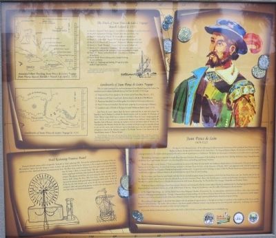
2. Text of Ponce de Leon Poster 2 (photo #8)
March 3 - April 2, 1513
(1) March 3 - Departed "Punta Aguada” (Puerto Rico) on a heading
of northwest by north.
(2) March 8 - Anchored at “El Viego" (Grand Turk) after a 3 1/2 days’ Sail.
(3) March 9 - Anchored at “Caycos” (E. Caicos) after an easy day's sail.
(4) March 10 - Anchored at “Yaguna” (N. Caicos) again after an easy day’s sail.
(5) March 11-12 - Hove-to off “Amaguayo” (Mayaguano) after an overnight sail.
(6) March 13 - Passed “Manegua” (Samana Cay) during an overnight sail.
(7) March 14 - 2'5 - Anchored at "Guanahani" (San Salvador), provisioned and re-rigged the vessels for the anticipated long ocean passage to Beimeni.
(8) March 27 - Passed “unidentified island” (Eleuthera) on a heading of northwest.
(9) March 29-30 - Hove-to during storm, changed heading to west-northwest.
(10) April 2-3 - Anchorage and landing, 28 degrees latitude, south of Cape Canaveral.
This annotated chart is from the research of the Florida historian, Colonel Douglas T. Peck, and is contained in his book: Ponce de León and the Discovery of Florida (1993).
This is a scaled drawing of the northwest portion of Peter Martyr's map of the Indies. The numbered arrows indicate landmarks during Juan Ponce de León's 1513 voyage.
(1) Departure from Punta Aguada on the western end
of Puerto Rico, March 3, 1513.
(2) Anchored at El Viejo (Grand Turk), the first island on the Banks of the Babueca.
(3) Passed and identified (from Indian guides) five islands in the Lucayan (Bahamas).
(4) Stayed 10 days on Guanahani (San Salvador) preparing for ocean passage to Beimeni.
(5) Landed on coast of Florida at 28 degrees latitude (Melbourne Beach), April 3, 1513.
Juan Ponce de León's charter from the Crown authorized him to seek and conquer the legendary land of Beimeni to extend the Spanish empire, with no mention of a Fountain of Youth. Martyr’s map which was in existence well before Ponce de León's voyage graphically shows why he set his course in a northwesterly direction into unknown waters seeking the legendary land of Beimeni. And when he landed on the low and barren shore of Florida in the exact position that Beimeni should have been (as shown on Martyr's map) he naturally realized it was not the exotic land of Beimeni and at first believing it was just another relatively unimportant island of the Bahamas, named it "La Florida" because it was discovered in the Spanish Easter season of “Pascua Florida.”
The annotated Peter Martyr map is from the research of the Florida historian, Colonel Douglas T. Peck and is contained in “Reconstruction and Analysis of the 1513 Discovery Voyage of Juan
Ponce de León, The Florida Historical Quarterly, Vol. LXXI, #2 (1992), and in Colonel Peck’s book: Ponce de León and the Discovery of Florida (1993). All copyrighted material printed and reproduced with permission from Douglas T. Peck.
During the fifteenth century, sailors navigated by "deduced" or “dead” reckoning (DR). This was the method used by most sailors of this era. DR navigation requires that each change in course, distance, and speed be recorded by the helmsman so the navigator could plot the ship's position on a chart. Speed and distance was measured every hour. The officer of the watch would keep track of the speed and course sailed every hour by using a toleta or traverse board. This was a simple visual recording device; a peg-board with holes radiating from the center along every point of the compass. The peg was moved from the center along the course traveled, for the distance made during that hour. After four hours, another peg was used to represent the distance made good in leagues during the whole watch. At the end of the day, the total distance and course for the day was transferred to the navigator's chart and each ending position would be the starting point for the next day's course and distance measurement.
1474-1521
On
April 2, 2013 Brevard County will be celebrating the Quincentennial Anniversary of the Landing of Juan Ponce de León at Melbourne Beach, Florida and The President of the United States, The King and Queen of Spain, The Governor of Florida, as well as other governmental, civic leaders and the general public will be invited to participate in a Celebration. We believe the Anniversary is of interest to our entire nation to participate.
The weeklong Celebration is expected to include Mass, Opening Ceremony, Re-enactment of the Landing, Air Force Fly Over, Tall Ship Exhibition, Gala, Cultural Festivals, Exhibitions from Local Schools, Arts and Crafts, Unveiling of the Statue and Building, and Closing Ceremony.
Florida Historian Colonel Douglas T. Peck concluded from his research that Ponce de León landed near Melbourne Beach which is 125 miles south of the previously accepted landing site of St. Augustine. Colonel Peck’s findings are found in his book “Ponce de León and the Discovery of Florida (1993)” and registered in the Oxford Companion to Exploration (2007) An Encyclopedia of Worldwide Exploration and Discovery”. In agreement with his findings, on April 2, 2005 the Florida Department of State issued a Historical Land Marker recognizing Melbourne Beach as the probable location of Juan Ponce de León's landing.
On this journey Juan Ponce de León brought with him the first Spanish European woman, Juana Jimenez, and the first free black African man, Juan Garrido, who set foot on the Florida Peninsula. Juan Ponce de León also achieved being the First Governor of Puerto Rico 1508, First European to set foot in the Northern Hemisphere, First Governor of Florida 1513, and First Chief Justice of Florida. He discovered the Gulf Stream, Biscayne Bay, The Florida Keys, Dry Tortugas, Tampa Bay, and Charlotte Harbor.
With direct relation to the Voyage of Juan Ponce de León's discovery and naming of La Florida, known today as Florida, he established the first Thanksgiving and the first school, hospital and bank on this land that we now call the United States of America. Along with his discovery came the cradle of Christianity in North America.
U.T.B. - United Third Bridge, Inc. and the Florida Puerto Rican/Hispanic Chamber of Commerce, Inc. are organizations committed to excellence, with a clear vision and a passion for delivering outstanding results. Through a Memorandum of Understanding with the Brevard County Board of County Commissioners, the organizations jointly support the desire to provide an educational facility dedicated to Hispanic Cultural heritage through corporate, philanthropic, donations and grant funding.
We are asking for your support to help fund these projects with the purchase of engraved pavers or through sponsorships to contribute to the completion of the Statue and the Hispanic Cultural facility. The facility will contribute to the future growth of Brevard County’s long lasting tourism and will provide employment, marketing, and outreach opportunities for all businesses and residents within the local community.
If you need additional information, please call 321-863-5165 or 321-253-0363; or email [email protected] or [email protected].
Captions:
Annotated Chart Tracking Juan Ponce de León’s Voyage from Puerto Rico to Florida – March 3 to April 2, 1513
Landmarks of Juan Ponce de León’s Voyage in 1513
— Submitted July 31, 2017, by J. Makali Bruton of Accra, Ghana.
Credits. This page was last revised on June 5, 2019. It was originally submitted on March 3, 2012, by Jamie Cox of Melbourne, Florida. This page has been viewed 3,257 times since then and 105 times this year. Last updated on October 19, 2013, by Jamie Cox of Melbourne, Florida. It was the Marker of the Week April 5, 2015. Photos: 1. submitted on March 3, 2012, by Jamie Cox of Melbourne, Florida. 2, 3. submitted on June 5, 2019, by Tim Fillmon of Webster, Florida. 4, 5, 6. submitted on March 3, 2012, by Jamie Cox of Melbourne, Florida. 7, 8, 9. submitted on January 3, 2014, by Jamie Cox of Melbourne, Florida. • Bernard Fisher was the editor who published this page.
