Anchorage, Alaska — Northwest (North America)
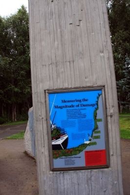
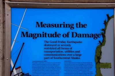
Measuring the Magnitude of Damage
The Good Friday Earthquake destroyed or severely restricted all forms of transportation, utilities and communications over a large part of south-central Alaska.
Communications and Utilities
The complete or partial loss of necessary services greatly affected Alaskan’s emotional and physical well-being. Telephone, water, sewer, electricity and gas systems were disrupted throughout Southcentral Alaska. Despite wide-spread damage, the telephone system was patched together in a few hours. However, water and sewer lines required weeks or months to repair. Because of the immediate loss of electric power in Anchorage there were almost no fires following the earthquake. Power companies, working with the military, able to restore partial electrical service in a few days.
Roads and Ports
Severely crippling Southcentral Alaska, the earthquake damaged all major and most secondary roads. Of 204 bridges, 141 were destroyed or damaged. A few segments of road built on bedrock were passable, but those underlaid by soft sediments subsided, and were not usable. In the areas where the land dropped as much 13 feet, roads were flooded. Most roads were made serviceable by summer 1964.
Southcentral ports were wiped out - only the port of Anchorage was partially operational after the earthquake. Seward, Valdez, Kodiak, Cordova and Whittier suffered the complete loss of their ports and adjacent fishing, railroad and industrial facilities. The loss of Seward and Valdez was crippling, as these were the only all-weather ice-free ports with railroad and road access to Alaska’s interior. The destruction of these ports permanently changed the economic pattern of water and rail transport in Alaska, bringing major shipping to the port of Anchorage.
Airports
Alaska was fortunate that most airports were spared major damage. Air transportation remains vitally important to Alaska. It was the airport facilities, rather than the runways, that were damaged by the four minutes of violent shaking. The single greatest loss was the Anchorage Central Control Tower which collapsed and killed one controller. Nearly all airports were operational within a few hours after the earthquake, allowing rescue operations to run smoothly.
Flora and Fauna Damage
The Good Friday Earthquake caused great destruction not only to works of man, but to the natural environment of Southcentral Alaska.
Richter vs Mercalli
These are two common methods of defining an earthquake.
The Richter scale quantitatively rates the magnitude (the energy released) of an earthquake. The scale measures the seismic waves recorded by various seismic graphic stations averaged to 60 miles from the epicenter. The energy released from a magnitude 5.0 earthquake is thirty times greater than that from a magnitude 4.0 earthquake. In nineteen sixty-four, the Good Friday earthquake measured between 8.3 and 8.6, making it one of the five largest earthquakes since eighteen eighty. Some scientists have recently upgraded the Richter of this earthquake to 9.2, which would make it the largest earthquake in recorded history.
The modified Mercalli scale quantitatively rates the intensity of an earthquake, by a visual assessment of damage to structures, to the ground surface, and to living beings. This scale has values from I to XII: a quake rating VI is felt by all, frightens many, moves heavy furniture, damages chimneys and stone walls, but structural damage to buildings is slight. The Good Friday Earthquake was estimated to have an intensity of XI.
Topics. This historical marker is listed in this topic list: Disasters. A significant historical year for this entry is 1964.
Location. 61° 11.906′ N, 149° 58.821′ W. Marker is in Anchorage, Alaska. Marker is on West Northern Lights Boulevard. This marker is located in Earthquake Park on W Northern Lights Blvd. It is also accessible from the Tony Knowles Bicycle Trail. Parking is available on W Northern Lights Blvd. (N 61° 11.756 W 149° 58.578). From the parking lot, follow the paved path to the marker. Touch for map. Marker is in this post office area: Anchorage AK 99502, United States of America. Touch for directions.
Other nearby markers. At least 8 other markers are within 5 miles of this marker, measured as the crow flies. The Earth Did Quake (a few steps from this marker); Turnagain Heights Slide (a few steps from this marker); Tsunami! (within shouting distance of this marker); Anchorage Aloft! (about 400 feet away, measured in a direct line); Oscar Gill House (approx. 2.6 miles away); Captain James Cook (approx. 2.9 miles away); Resolution Park 1776 / 1778 (approx. 2.9 miles away); What is this “Rock Man”? (approx. 4.3 miles away). Touch for a list and map of all markers in Anchorage.
Also see . . . Great Alaskan earthquake of 1964. You Tube video (Submitted on October 13, 2013, by Byron Hooks of Sandy Springs, Georgia.)
Credits. This page was last revised on October 16, 2020. It was originally submitted on October 13, 2013, by Byron Hooks of Sandy Springs, Georgia. This page has been viewed 727 times since then and 19 times this year. Last updated on October 27, 2013, by Byron Hooks of Sandy Springs, Georgia. Photos: 1, 2, 3. submitted on October 13, 2013, by Byron Hooks of Sandy Springs, Georgia. • Syd Whittle was the editor who published this page.


