Lakehead-Lakeshore in Shasta County, California — The American West (Pacific Coastal)
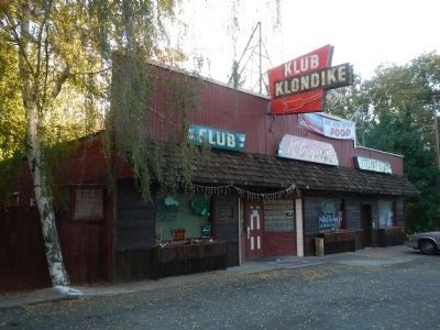
Klub Klondike
In 1948 Kris and Scotty Scott bought the property and opened a gas station and bar and restaurant they named Klub Klondike. The first Lakehead post office and library were located in the building. It is said that in the early 1950’s there was a brothel upstairs – construction workers and miners frequented the premises – the room still exists in the attic.
Erected 2006 by E Clampus Vitus, Lassen-Loomis Chapter 1934.
Topics and series. This historical marker is listed in these topic lists: Entertainment • Industry & Commerce. In addition, it is included in the E Clampus Vitus series list. A significant historical year for this entry is 1948.
Location. 40° 54.376′ N, 122° 22.99′ W. Marker is in Lakehead-Lakeshore, California, in Shasta County. Marker is at the intersection of Main Street and Moody Lane, on the left when traveling south on Main Street. Touch for map. Marker is at or near this postal address: 21375 Main Street, Rota MP 96951, United States of America. Touch for directions.
Other nearby markers. At least 8 other markers are within 12 miles of this marker, measured as the crow flies . Stone Turnpike Memorial Freeway (approx. 1.1 miles away); a different marker also named Stone Turnpike Memorial Freeway (approx. 8½ miles away); Water Tank (approx. 10.7 miles away); The Sawmill (approx. 10.8 miles away); CCC Camp (1934-1939) (approx. 10.8 miles away); Sims Bridge: A CCC First (approx. 10.9 miles away); Pioneers Who “Held the Ribbons” (approx. 11 miles away); Southern Hotel and Stage Station (approx. 11.1 miles away).
Credits. This page was last revised on June 16, 2016. It was originally submitted on October 29, 2013, by Barry Swackhamer of Brentwood, California. This page has been viewed 968 times since then and 47 times this year. Photos: 1, 2. submitted on October 29, 2013, by Barry Swackhamer of Brentwood, California. • Syd Whittle was the editor who published this page.

