Lutherstadt Wittenberg in Wittenberg, Saxony-Anhalt, Germany — Central Europe
Jugendherberge
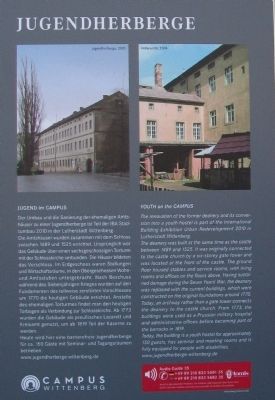
The renovation of the former deanery and its conversion into a youth hostel is part of the International Building Exhibition Urban Redevelopment 2010 in Lutherstadt Wittenberg.
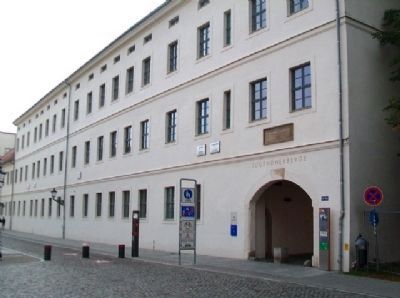
The deanery was built at the same time as the castle between 1489 and 1525. It was originally connected to the castle church by a six-storey gate tower and was located at the front of the castle. The ground floor housed stables and service room, with living rooms and offices on the floors above. Having sustained damage during the Seven Years’ War, the deanery was replaced with the current buildings, which were constructed on the original foundations around 1770. Today, an archway rather than a gate tower connects the deanery to the castle church. From 1773, the buildings were used as a Prussian military hospital and administrative offices before becoming part of the barracks in 1819.
Today, the building is a youth hostel for approximately 150 guests, has seminar and meeting rooms and is fully equipped for people with disabilities.
——————————
Jugend im Campus
Der Umbau und die Sanierung der ehemaligen Amsthäuser zu einer Jugendherberge ist Teil der IBA Stadtumbau 2010 in der Lutherstadt Wittenberg.
Die Amtshäuser wurden zusammen mit dem Schloss zwischen 1489 and 1525 errichtet. Ursprünglich war das Gebäude über einen sechsgeschossigen Torturm mit der Schlosskirche verbunden. Die Häuser bildeten das Vorschloss. Im Erdgeschoss waren Stallungen und Wirtschaftsräume, in den Obergeschossen Wohn- und Amtsstuben untergebracht. Nach Beschuss während des Siebenjährigen Krieges wurden auf den Fundamenten des teilweise zerstörten Vorschlosses um 1770 die heutigen Gebäude errichtet. Anstelle des ehemaligen Torturmes findet man den heutigen Torbogen als Verbindung zur Schlosskirche. Ab 1773 wurden die Gebäude als preußisches Lazarett und Kreisamt genutzt, um ab 1819 Teil der Kaserne zu werden.
Heute wird hier eine barrierefreie Jugendherberge für ca. 150 Gäste mit Seminar- und Tagungsräumen betrieben.
www.jugendherberge-wittenberg.de
Erected by Campus Wittenberg. (Marker Number 3.)
Topics. This historical marker is listed in this topic list: Notable Buildings. A significant historical year for this entry is 2010.
Location. 51° 51.984′ N, 12° 38.319′ E. Marker is in Lutherstadt Wittenberg, Sachsen-Anhalt (Saxony-Anhalt),
in Wittenberg. Marker is at the intersection of Schlossstraße and Schloßplatz, on the left when traveling west on Schlossstraße. Touch for map. Marker is at or near this postal address: Schlossstraße 14-15, Lutherstadt Wittenberg ST 06886, Germany. Touch for directions.
Other nearby markers. At least 8 other markers are within walking distance of this marker. Olga Gebauer (within shouting distance of this marker); Castle Church in Wittenberg (within shouting distance of this marker); Michel Ney (within shouting distance of this marker); The Castle Gate, also called Coswig Gate (within shouting distance of this marker); Wilhelm Eduard Weber (about 150 meters away, measured in a direct line); Wilhelm-Weber-Haus (about 150 meters away); Thomas Müntzer (about 210 meters away); Johann Schneidewin (about 210 meters away). Touch for a list and map of all markers in Lutherstadt Wittenberg.
Also see . . . Campus Wittenberg. (Submitted on October 30, 2013, by William Fischer, Jr. of Scranton, Pennsylvania.)
Credits. This page was last revised on January 7, 2024. It was originally submitted on October 30, 2013, by William Fischer, Jr. of Scranton, Pennsylvania. This page has been viewed 526 times since then and 8 times this year. Photos: 1, 2, 3. submitted on October 30, 2013, by William Fischer, Jr. of Scranton, Pennsylvania.


