Fayetteville in Cumberland County, North Carolina — The American South (South Atlantic)
Burning of Clarendon Bridge
Confederates Evacuate Fayetteville
— Carolinas Campaign —
The Carolinas Campaign began on February 1, 1865, when Union Gen. William T. Sherman led his army north from Savannah, Georgia, after the March to the Sea. Sherman’s objective was to join Gen. Ulysses S. Grant in Virginia to crush Gen. Robert E. Lee’s Army of Northern Virginia. Scattered Confederate forces consolidated in North Carolina, the Confederacy’s logistical lifeline, where Sherman defeated Gen. Joseph E. Johnston’s last-ditch attack at Bentonville. After Sherman was reinforced at Goldsboro late in March, Johnston saw the futility of further resistance and surrendered near Durham on April 26, essentially ending the Civil War.
(main text)
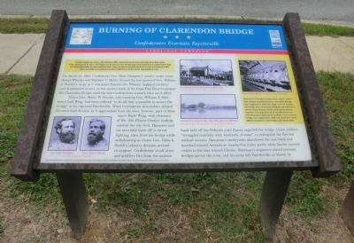
On March 12, 1865, Confederate Gen. Wade Hampton’s cavalry under Gens. Joseph Wheeler and Matthew C Butler formed the rear guard of Gen. William J. Hardee’s Corps as it evacuated Fayetteville. Wheeler deployed artillery and dismounted cavalry on the eastern bank of the Cape Fear River to protect the Clarendon Bridge until the last Confederates crossed, then set it afire.
Union Gen. Henry W. Slocum, commanding Gen. William T. Sherman’s Left Wing, had been ordered “to do all that is possible to secure the bridge” as he captured Fayetteville. When Confederate skirmishers delayed Slocum’s lead division as it approached from the west, however, part of Sherman’s Right Wing, with elements of the 15th Illinois Cavalry leading, entered the city first. Hampton and his men held them off in street fighting, then fired the bridge while withdrawing as Union Gen. Giles A. Smith’s infantry division arrived in support. Confederate small arms and artillery fire from the eastern bank held off the Federals until flames engulfed the bridge. Union soldiers “struggled manfully with washtubs of water” to extinguish the fire but without success. Hampton’s cavalrymen abandoned the east bank and marched toward Averasboro twenty-five miles north, while Butler covered routes to the east toward Clinton. Sherman’s engineers placed pontoon bridges across the river, and his army left Fayetteville on March 14.
(captions)
(lower left) Gen. Wade Hampton and Gen. Giles A. Smith Courtesy Library of Congress
(center) Burning of Second Clarendon Bridge, 1909 Courtesy North Carolina Office of Archives & History
(center) Second Clarendon Bridge, 1866-1909, photo of 1908 flood Fayetteville Area Transportation & Local History Museum
(upper right) Town Lattice Truss - Courtesy Library of Congress
Named for Clarendon County, from which Cumberland County was later formed. Clarendon Bridge was completed in 1819. This large, covered wooden toll bridge
was constructed using the patented Town Lattice System, which used planks pinned together with pegs instead of the laborious mortise-and-tenon construction method. A new covered bridge was completed in 1866 and stood here until 1909. It remained a toll bridge until about 1885.
Erected by North Carolina Civil War Trails.
Topics and series. This historical marker is listed in these topic lists: Bridges & Viaducts • War, US Civil. In addition, it is included in the North Carolina Civil War Trails series list. A significant historical month for this entry is February 1858.
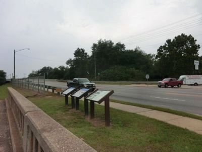
Location. 35° 2.813′ N, 78° 51.38′ W. Marker is in Fayetteville, North Carolina, in Cumberland County. Marker is at the intersection of Person Street and Dunn Road, on the left when traveling west on Person Street. Touch for map. Marker is at or near this postal address: 1122 Person Street, Fayetteville NC 28312, United States of America. Touch for directions.
Other nearby markers. At least 8 other markers are within 2 miles of this marker, measured as the crow flies. Campbelton (approx. 0.3 miles away); Flora Macdonald (approx. one mile away); Henry Evans (approx. 1.1 miles away); Cross Creek Linear Park (approx. 1.1 miles away); The Fayetteville Independent Light Infantry Company (approx. 1.1 miles away); Parade Ground (approx. 1.1 miles away); Cross Creek Cemetery
(approx. 1.1 miles away); Warren Winslow (approx. 1.2 miles away). Touch for a list and map of all markers in Fayetteville.
Credits. This page was last revised on June 16, 2016. It was originally submitted on November 24, 2013, by Don Morfe of Baltimore, Maryland. This page has been viewed 977 times since then and 55 times this year. Photos: 1, 2, 3. submitted on November 24, 2013, by Don Morfe of Baltimore, Maryland. • Bernard Fisher was the editor who published this page.


