East Peralta in Oakland in Alameda County, California — The American West (Pacific Coastal)
Early Harbor
Inscription.
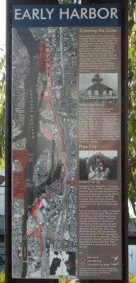
Creating the Cove
The transformation of the estuary from industrial harbor to recreational waterway is a major trend in Oakland’s history. The change began at this spot. The Oakland Municipal Yacht Harbor – the city’s first public marina – opened here in 1930. Developed by the Port of Oakland, the marina adjoined the moorage of the Oakland Yacht Club, founded in 1913 with Jack London as one of its early members. In the 1970s and 1980s, the Port redeveloped the shoreline of Brooklyn Basin as Embarcadero Cove, a linked series of marinas that included the one in front of you.
The Port’s Embarcadero Cove project borrowed its name from a private development several hundred yards east of here. Opened in 1970, old Embarcadero Cove is notable for its collection of historic buildings which were moved to the site from elsewhere in the city and adapted to new uses. These include the Southern Pacific’s East Oakland station, several Victorian houses, and Oakland’s turn-of-the-century harbor lighthouse, which was brought by barge from West Oakland. The photograph depicts the lighthouse keeper’s wife on the veranda.
Pipe City
During the Great Depression, in the winter of 1932-33, around 200 unemployed men lived here. The men made their homes in large concrete pipes in the storage yard of the American Concrete and Steel Pipe Company. Their community attracted widespread attention and was one of the inspirations for the novel Co-op by Upton Sinclair.
Pipe City elected its own mayor. A volunteer police force kept the peace. Drunkenness, uncleanliness, and political soapboxing were punishable by eviction. Cash from odd jobs and donations of food and clothing were shared equally among the men, who in turn helped needy families. Also known as Miseryville, due to the physical hardships, Pipe City disbanded early in the spring of 1933, when buyers were found for the concrete pipe. “There'll be no hunger marching”, vowed Pipe City Mayor Dutch Jensen at the time. “Now warm weather’s coming, and we’ll be on our way.”
Topics. This historical marker is listed in this topic list: Waterways & Vessels. A significant historical year for this entry is 1930.
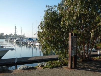
Location. Marker has been permanently removed. It was located near 37° 47.015′ N, 122° 14.6′ W. Marker was in Oakland, California, in Alameda County. It was in East Peralta. Marker was on Embarcadero, on the right when traveling south. Technically the marker is located on Alameda County Bicycle Route 5. Touch for map. Marker was at or near this postal address: 1895 Embarcadero, Oakland CA 94606, United States of America.
We have been informed that this sign or monument is no longer there and will not be replaced. This page is an archival view of what was.
Other nearby markers. At least 8 other markers are within walking distance of this location. Water & Rails / Brooklyn Basin (approx. ¼ mile away); Cryer & Sons (approx. 0.3 miles away); California Cotton Mill (approx. 0.3 miles away); Union Point (approx. half a mile away); Sígame/Follow Me (approx. half a mile away); 1920 Moving the World's Cargo (approx. 0.7 miles away); 1930 Where the World Comes to Oakland (approx. ¾ mile away); ATK Baseball Field (approx. 0.8 miles away). Touch for a list and map of all markers in Oakland.
Credits. This page was last revised on March 31, 2023. It was originally submitted on January 21, 2014, by Barry Swackhamer of Brentwood, California. This page has been viewed 621 times since then and 13 times this year. Photos: 1, 2. submitted on January 21, 2014, by Barry Swackhamer of Brentwood, California. 3. submitted on March 31, 2023, by Joseph Alvarado of Livermore, California. • Syd Whittle was the editor who published this page.


