Near Mitchell in Wheeler County, Oregon — The American West (Northwest)
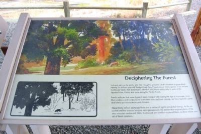
Deciphering the Forest
Fossils indicate that some type of trees changed little during the Age of Mammals. From that evidence and comparisons to modern trees and their settings, we have learned a great deal about past ecosystems and climates.
About thirty million years ago there was a period of significant global change. As the air cooled and the seasons became more pronounced, the earlier near-tropical plants of the area retreated southward. Many hardwoods and conifers replaced them, as did a whole new set of forest creatures.
Erected by National Park Service.
Topics. This historical marker is listed in this topic list: Natural Features.
Location. 44° 38.992′ N, 120° 16′ W. Marker is near Mitchell, Oregon, in Wheeler County. Marker can be reached from Bear Creek Road, 1.2 miles west of Bridge Creek - Burnt Ranch Road. Marker is located in the Painted Hills Unit of John Day Fossil Beds National Monument at the end of the road to the Painted Hills Overlook parking lot and trailhead; the above directions are to the intersection of Bear Creek Road and the Painted Hills Overlook road. Touch for map. Marker is in this post office area: Mitchell OR 97750, United States of America. Touch for directions.
Other nearby markers. At least 8 other markers are within 11 miles of this marker, measured as the crow flies. Pieces of the Puzzle (here, next to this marker); A Matter of Survival (here, next to this marker); Painted Hills Overlook (here, next to this marker); Painted by the Past (here, next to this marker); Who was John Day? (here, next to this marker); Fossils on the Frontier (approx. 0.8 miles away); Look Below the Surface (approx. 0.8 miles away); H.H. Wheeler (approx. 10.3 miles away). Touch for a list and map of all markers in Mitchell.
Credits. This page was last revised on October 20, 2020. It was originally submitted on February 12, 2014, by Duane Hall of Abilene, Texas. This page has been viewed 420 times since then and 9 times this year. Photos: 1, 2, 3, 4. submitted on February 12, 2014, by Duane Hall of Abilene, Texas.


