San Leandro in Alameda County, California — The American West (Pacific Coastal)
To Build a Dam
Lake Chabot Historical Walk
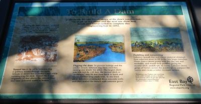
The rest of this marker consists of three illustrations accompanied by captions. The captions are presented here, left to right. Click on the image to enlarge it.
Clearing the area:
Workers “grubbed” (removed) 333 acres of brush and trees from the area to be flooded, to ensure rotting vegetation would not affect the quality of the reservoir’s water.
Tunnel No. 1:
In 1874, laborers dug a spillway tunnel through the rocky hillside to divert San Leandro Creek while constructing the dam. Tunnel No. 1 was originally 30 feet above the canyon floor and later delivered water to homes.
Digging the dam:
To prevent leakage and the creeks’ return, laborers dug three trenches nesting one inside the other. The largest ditch was 900 feet by 150 feet; the second ditch or “puddlepit” was 90 feet from bank to bank and about 140 feet long creek-wise. In the third ditch, laborers constructed three concrete walls and then sealed the trench with concrete grout.
Puddling and compacting:
Laborers spread clay and choice materials obtained from adjacent areas to fill the two larger trenches. Water from a stream pump kept the clay wet and workable, and would form puddles giving the second ditch, puddle-pit, its name. Laborers drove gangs of horses across the puddle-pit to compact the layers and create a water resistant surface.
”Historians say Chabot was watching some cattle trample across a muddy creek bottom when he got the idea for the primordial impacting plan.”
Oakland Tribune June 9, 1968.
Erected 2012 by East Bay Regional Park District.
Topics. This historical marker is listed in these topic lists: Industry & Commerce • Waterways & Vessels. A significant historical month for this entry is June 1888.
Location. 37° 43.804′ N, 122° 7.231′ W. Marker is in San Leandro, California, in Alameda County. Marker can be reached from Estudillo Avenue. The one mile Lake Chabot Historical Walk begins at the parking lot at the end of Estudillo Avenue. This marker is about one mile from the beginning of the trail. Touch for map. Marker is at or near this postal address: 1799 Estudillo Avenue, San Leandro CA 94577, United States of America. Touch for directions.
Other nearby markers. At least 8 other markers are within walking distance of this marker. Transporting the Water (here, next to this marker); Chabot Dam (a few steps from this marker); Of Fins and Flippers (about 400 feet away, measured in a direct line); Taming the Waters’ Flow
(about 700 feet away); Yem-Po: Chinese Labor Camp (approx. 0.2 miles away); Tunnel No. 1 Control Shaft (approx. 0.2 miles away); A Zoo, a Monkey, and a Mansion Here Too! (approx. 0.2 miles away); Filtration Basins (approx. 0.4 miles away). Touch for a list and map of all markers in San Leandro.
Credits. This page was last revised on October 13, 2021. It was originally submitted on February 14, 2014, by Barry Swackhamer of Brentwood, California. This page has been viewed 540 times since then and 30 times this year. Photos: 1, 2. submitted on February 14, 2014, by Barry Swackhamer of Brentwood, California. • Syd Whittle was the editor who published this page.

