Santa Fe in Santa Fe County, New Mexico — The American Mountains (Southwest)
Hitching Post at the End of the Trail
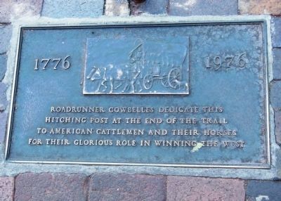
1776 – 1976
Inscription.
Roadrunner Cowbelles dedicate this hitching post at the end of the trail to American cattlemen and their horses for their glorious role in winning the West.
Erected by Roadrunner Cowbelles.
Topics. This historical marker is listed in this topic list: Settlements & Settlers.
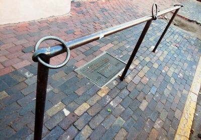
Location. 35° 41.269′ N, 105° 56.256′ W. Marker is in Santa Fe, New Mexico, in Santa Fe County. Marker is at the intersection of Washington Avenue and East Palace Avenue, on the right when traveling south on Washington Avenue. This marker is embedded into the sidewalk along the west side of Washington Avenue, adjacent to the east side of the Palace of the Governors Building, in front of the entrance to the Palace of the Governors Print Shop. It is best viewed when walking and could easily be missed when driving on the street. Touch for map. Marker is in this post office area: Santa Fe NM 87501, United States of America. Touch for directions.
Other nearby markers. At least 8 other markers are within walking distance of this marker. Site of Santa Fe’s First Chapel (a few steps from this marker); Fray Angélico Chávez (within shouting distance of this marker); Cut Stone Facade with Quoin (within shouting distance of this marker); 109 East Palace (within shouting distance of this marker); A Building Stood Here Before 1680 (within shouting distance of this marker); Annexation of New Mexico (within shouting distance of this marker); El Palacio Real (within shouting distance of this marker); Captain Diego Arias de Quiros (within shouting distance of this marker). Touch for a list and map of all markers in Santa Fe.
More about this marker. The Roadrunner Cowbelles are the Santa Fe Women's Auxiliary of the Cattlemen's Association.
Also see . . .
1. A History of the Santa Fe Trail. Santa Fe Trail Association website entry:
In 1879, the Atchison, Topeka, and Santa Fe (A.T.& SF) Railroad crept over Raton Pass and in 1880 the A.T.& SF reached Lamy station south of Santa Fe, ending long distance freighting over the plains - the Santa Fe Trail was at an end. For almost 60 years the Santa Fe Trail was the conduit which brought goods to New Mexico and the southwest and had sent back silver, furs, and mules. But ideas were also exchanged across this route along with culture. New Mexicans were exposed to “Yankees” and their way of doing business long before the invasion took place. Raw Missouri farm boys were fascinated with the exotic city of Santa Fe once they got over the shock of its appearance as a large
brick kiln. (Submitted on April 29, 2018, by Cosmos Mariner of Cape Canaveral, Florida.)
2. Santa Fe Trail. Wikipedia entry:
The Santa Fe Trail was a 19th-century transportation route through central North America that connected Independence, Missouri with Santa Fe, New Mexico. Pioneered in 1821 by William Becknell, it served as a vital commercial highway until the introduction of the railroad to Santa Fe in 1880. Santa Fe was near the end of the El Camino Real de Tierra Adentro, which carried trade from Mexico City. (Submitted on April 29, 2018, by Cosmos Mariner of Cape Canaveral, Florida.)
Credits. This page was last revised on November 28, 2023. It was originally submitted on April 2, 2014, by Cosmos Mariner of Cape Canaveral, Florida. This page has been viewed 558 times since then and 26 times this year. Photos: 1. submitted on April 2, 2014, by Cosmos Mariner of Cape Canaveral, Florida. 2. submitted on April 3, 2014, by Cosmos Mariner of Cape Canaveral, Florida. • Bill Pfingsten was the editor who published this page.

