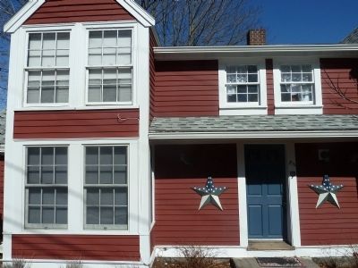
Rockport in Essex County, Massachusetts — The American Northeast (New England)
Benjamin Tarr House
1630 - 1930
Erected 1930 by Massachusetts Bay Colony Tercentenary Commission.
Topics and series. This historical marker is listed in this topic list: War, US Revolutionary. In addition, it is included in the Massachusetts Bay Colony—Tercentenary Commission Markers series list. A significant historical year for this entry is 1630.
Location. 42° 39.303′ N, 70° 36.528′ W. Marker is in Rockport, Massachusetts, in Essex County. Marker is on South Street, on the right when traveling north. This historic home has been used in recent times as rental apartments, a tea house, and home to a local newspaper. The current owners have refurbished it and portions are for rent as a vacation home. Touch for map. Marker is at or near this postal address: 23 South Street, Rockport MA 01966, United States of America. Touch for directions.
Other nearby markers. At least 8 other markers are within walking distance of this marker. Town Wharves (approx. 0.4 miles away); Cannon from the U.S.S. Constitution (approx. 0.4 miles away); Harvey Park (approx. 0.4 miles away); Rockport World War I & II Memorial (approx. 0.4 miles away); Old Stone Fort (approx. half a mile away); Straitsmouth Island (approx. half a mile away); Bear Skin Neck (approx. half a mile away); The First Settlers of Sandy Bay (approx. 0.6 miles away). Touch for a list and map of all markers in Rockport.
More about this marker. This historical marker was destroyed during a storm in 2001, but has been replaced.
Credits. This page was last revised on September 30, 2020. It was originally submitted on April 21, 2014, by Larry Wilson of Wareham, Massachusetts. This page has been viewed 1,367 times since then and 80 times this year. Photos: 1, 2, 3, 4, 5. submitted on April 21, 2014, by Larry Wilson of Wareham, Massachusetts. • Bill Pfingsten was the editor who published this page.
