Gordon in Houston County, Alabama — The American South (East South Central)
Gordon Cemetery / Early Gordon Leaders
(side 1)
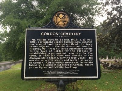
Gordon Cemetery
Mr. William Wood (b. 22 Mar. 1826, d. 15 Oct. 1885), a prominent Gordon businessman, donated one acre of land located north of the town center adjacent to the old river road, now U.S. Highway 95, from his large plantation estate to the Town of Gordon for the purpose of establishing a permanent cemetery for the town. In 1859 Mr. Wood was elected to the Alabama State Senate, serving four years. He was also an active Mason and served as mayor of Gordon. A prosperous merchant, he established two riverboat landings at Gordon, known as the Upper and Middle landings.
(side 2)
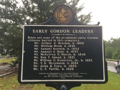
Below are some of the prominent early Gordon
citizens buried in this cemetery.
Mr. Arthur J. Bowdon, b. 1809
Mr. William Wood, b. 1826
Mr. Samuel Bowdon, b. 1835
Mr. Samuel J. Hall, b. 1837
Mr. McKelvey C. Marsh, b. 1848
Mr. Ben F. Snead, b. 1851
Mr. William G. Roundtree, Jr., b. 1852
Dr. T. R. McLendon, b. 1854
Mr. John R. Espy, b. 1856
Mr. E. F. Tuttle, b. 1858
Erected 2000 by Descendants of the below Gordon Families. The Dothan Landmarks Foundation and the Historic Chattahoochee Commission.
Topics. This historical marker is listed in these topic lists: Cemeteries & Burial Sites • Settlements & Settlers. A significant historical date for this entry is March 22, 1826.
Location. 31° 9.231′ N, 85° 6.072′ W. Marker is in Gordon, Alabama, in Houston County. Marker is on Main Street (Alabama Route 95) 0.1 miles north of Hall Street (County Road 81), on the left when traveling north. Touch for map. Marker is at or near this postal address: 2025 Main Street, Gordon AL 36343, United States of America. Touch for directions.
Other nearby markers. At least 8 other markers are within 9 miles of this marker, measured as the crow flies. Gordon Baptist Church (approx. 0.6 miles away); Liberty Baptist Church (approx. 4˝ miles away); Confederate Navy Yard, Saffold (approx. 5 miles away in Georgia); Ashford United Methodist Church (approx. 8.2 miles away); Incorporation of Ashford/Ashford - a Unique Name (approx. 8.2 miles away); Ashford Centennial (approx. 8.2 miles away); Ashford Depot (approx. 8.3 miles away); The Chacato People (approx. 8˝ miles away).
Credits. This page was last revised on June 16, 2016. It was originally submitted on May 2, 2014, by Mark Hilton of Montgomery, Alabama. This page has been viewed 805 times since then and 32 times this year. Photos: 1, 2, 3. submitted on May 2, 2014, by Mark Hilton of Montgomery, Alabama. • Bernard Fisher was the editor who published this page.


