Potomac West in Alexandria, Virginia — The American South (Mid-Atlantic)
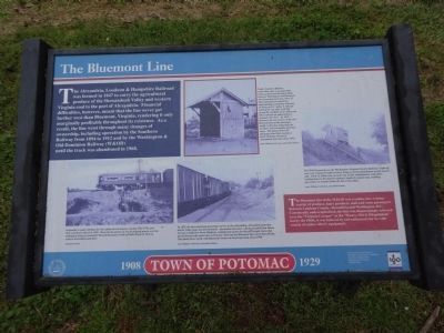
The Bluemont Line
(sidebar)
The Bluemont line of the W&OD was a sedate, low-volume carrier of produce, dairy products, mail and some passengers between Loudoun County, Alexandria and Washington, D.C. Consistently undercapitalized, the line was disparagingly referred to as the “Virginia Creeper” or the “Weary, Old & Dilapidated,” but by the 1960s, it was beloved by rail enthusiasts for its wide variety of rather elderly equipment.
Erected 2008 by City of Alexandria.
Topics and series. This historical marker is listed in this topic list: Railroads & Streetcars. In addition, it is included in the Virginia, The City of Alexandria series list. A significant historical year for this entry is 1847.
Location. 38° 49.832′ N, 77° 3.342′ W. Marker is in Alexandria, Virginia. It is in Potomac West. Marker is on East Raymond Avenue, 0.1 miles east of DeWitt Avenue, on the right when traveling west. The marker is at the one end of the unpaved trail on the former railroad right-of-way between present-day Jeff Davis Hwy (US 1) and Raymond Avenue, now known as Mt. Jefferson Park & Greenway. It also marks the beginning of a paved trail that continues down the former railroad right-of-way to Commonwealth Avenue. Touch for map. Marker is in this post office area: Alexandria VA 22301, United States of America. Touch for directions.
Other nearby markers. At least 8 other markers are within walking distance of this marker. The Triangle Site (approx. ¼ mile away); St. Asaph Racetrack (approx. ¼ mile away); Corporal Charles William Hill (approx. ¼ mile away); Schools in the Town of Potomac (approx. ¼ mile away); Captain Rocky Versace Plaza and Vietnam Veterans Memorial (approx. ¼ mile away); Potomac Yard History (approx. ¼ mile away); a different marker also named St. Asaph Racetrack (approx. ¼ mile away); The Town of Potomac / Mount Vernon Avenue (approx. 0.3 miles away). Touch for a list and map of all markers in Alexandria.
More about this marker. (captions)
(lower left) Originally a steam railroad, the line added electrical power during 1912-1916, and then switched to diesel in 1942. Here electric motor car No. 43 gingerly passes over the underpass being excavated for Russell Road (just south of Glebe Road) in 1916 en route to Alexandria Junction. National Archives
(center top) Under Southern Railway ownership, four to six passenger trains passed each direction daily between Washington and Bluemont via Alexandria Junction. Most of these operated on something approaching a commuter schedule, arriving in D.C. before 9 AM and leaving the city after 4:30 PM, giving the residents of St. Elmo and other suburbs an opportunity to commute into D.C.. In 1912, however, the new owners of the line diverted most of the passenger traffic to Rosslyn, bypassing the St. Elmo and Alexandria Junction stops. This photo shows the passenger shed that stood just north of Hume Avenue at Alexandria Junction about 1918. Ames Williams Collection, Alexandria Library
(center bottom) In 1932, the last remaining passenger service at the Alexandria, Alexandria Junction and St. Elmo stops was dicontinued. Alexandria Junction, which extended from Hume Avenue to Jefferson Davis Highway, remained in service for the few freight trains that moved between the main lines at Potomac Yard and the Bluemont line out to Purcellville. This photo faces north, with Raymond Avenue in the foreground, about 1960. Ames Williams Collection, Alexandria Library
(upper right) The W&OD passed over the Washington-Virginia Electric Railway's right-of-way (now Commonwealth Avenue) using a raised embankment on the eastern side. Their St. Elmo stop sat at the top of this embankment, with stairs leading down to the electric railway's similarly named stop, enabling passengers to transfer from one line to the other. Ames Williams Collection, Alexandria Library
Also see . . . The Washington & Old Dominion Railroad in Del Ray. "Del Ray" is the neighborhood of the City of Alexandria in which the marker is located. (Submitted on May 10, 2014, by Brian Cubbage of Alexandria, Virginia.)
Additional commentary.
1. Addition Marker Inscriptions
Produced for the Town of Potomac Centennial in 2008 by the City of Alexandria. Research and text by Leland Ness
— Submitted May 10, 2014, by Brian Cubbage of Alexandria, Virginia.
Credits. This page was last revised on January 27, 2023. It was originally submitted on May 10, 2014, by Brian Cubbage of Alexandria, Virginia. This page has been viewed 927 times since then and 46 times this year. Photos: 1, 2, 3. submitted on May 10, 2014, by Brian Cubbage of Alexandria, Virginia. • Bernard Fisher was the editor who published this page.


