Parkersburg in Wood County, West Virginia — The American South (Appalachia)
Fort Boreman
Protecting the B&O Railroad
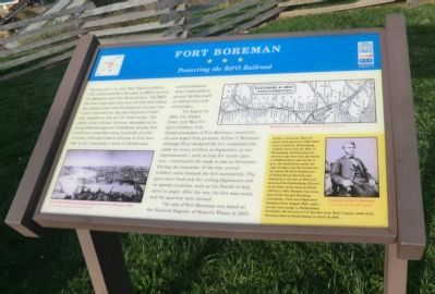
On August 21, 1863, Col. Daniel Frost, 11th West Virginia Infantry, took formal possession of Fort Boreman (named for the new state’s first governor, Arthur I. Boreman.) Although Frost declared the fort completed and ready for heavy artillery in September, in fact improvements—such as huts for winter quarters—continued to be made as late as November. During the remainder of the war, several artillery units manned the fort successively. The guns were fired only for visiting dignitaries and on special occasions, such as the Fourth of July, never in anger. After the war, the fort was razed, and the quarters were burned.
The site of Fort Boreman was listed on the National Register of Historic Places in 2003.
(sidebar)
Arthur I. Boreman, West Virginia’s first governor (1863-1869), was a prominent Parkersburg resident. Born July 24, 1823, in Waynesburg, Pennsylvania, he moved at age four with his family to Middlebourne, just north of here. He studied law under his older brother and his brother-in-law James McNeill Stephenson of Parkersburg. Boreman was admitted to the bar in 1845 and practiced in Parkersburg. Elected to the first of his many political offices in 1855, Borman was president of the Second Wheeling Convention, First and Adjourned Sessions (June-August 1861), and a circuit court judge in Parkersburg thereafter. He served as a U.S. Senator from West Virginia (1868-1875), Boreman died in Parkersburg on April 19, 1896.
(captions)
(lower left) View of Parkersburg from Mount Logan (site of Fort Boreman), 1861 Courtesy West Virginia University Library.
(upper right) B&O Route Map, 1860 Courtesy B&O Railroad Museum
(lower right) Governor Arthur I. Boreman Courtesy Library of Congress
Erected by West Virginia Civil War Trails.
Topics and series. This historical marker is listed in these topic lists: Forts and Castles • Railroads & Streetcars • War, US Civil. In addition, it is included in the West Virginia Civil War Trails series list. A significant historical month for this entry is April 1892.
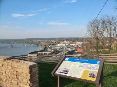
Location. 39° 15.755′ N, 81° 34.164′ W. Marker is in Parkersburg, West Virginia, in Wood County. Marker is on Fort Boreman Drive, one mile south of Robert Byrd Highway (U.S. 50). The marker is located in Fort Boreman Park. Touch for map. Marker is in this post office area: Parkersburg WV 26101, United States of America. Touch for directions.
Other nearby markers. At least 8 other markers are within walking distance of this marker. Parkersburg and the Civil War (here, next to this marker); Historic Parkersburg (West) Virginia (a few steps from this marker); The Beautiful Ohio River (a few steps from this marker); Historic Blennerhassett Island (a few steps from this marker); a different marker also named Fort Boreman (within shouting distance of this marker); Welcome (within shouting distance of this marker); William L. “Mudwall” Jackson (within shouting distance of this marker); Parkersburg in 1861 (within shouting distance of this marker). Touch for a list and map of all markers in Parkersburg.
Credits. This page was last revised on June 16, 2016. It was originally submitted on May 10, 2014, by Don Morfe of Baltimore, Maryland. This page has been viewed 669 times since then and 18 times this year. Photos: 1, 2, 3. submitted on May 10, 2014, by Don Morfe of Baltimore, Maryland. • Bernard Fisher was the editor who published this page.


